The content of these notes are solid, but formatting is not since they’re exported from Notion.
🗺️ Unit 1 — Thinking Geographically #
Developing Understanding
This first unit sets the foundation for the course by teaching students how geographers approach the study of places. Students are encouraged to reflect on the “why of where” to better understand geographic perspectives. Many other high school courses ask students to read and analyze data, but for this course, students also apply a spatial perspective when reading and analyzing qualitative and quantitative data. Students learn the ways information from data sources such as maps, tables, charts, satellite images, and infographics informs policy decisions such as voting redistricting or expanding transportation networks. They also learn about how people influence and are influenced by their environment; the resulting impact on topography, natural resources, and climate; and the differences between and consequences of environmental determinism and possibilism. Finally, students are introduced to the language of geography, learning discipline-specific terminology and applying that language to contemporary, real-world scenarios so they can better study population processes and patterns in the next unit.
BIG IDEA 1 Patterns and Spatial Organization (PSO)
- Why do geographers study relationships and patterns among and between places? BIG IDEA 2 Impacts and Interactions (IMP)
- How do geographers use maps to help them discover patterns and relationships in the world? BIG IDEA 3 Spatial Processes and Societal Change (SPS)
- How do geographers use a spatial perspective to analyze complex issues and relationships?
1.1 Introduction to Maps #
IMP 1A Geographers use maps and data to depict relationships of time, space, and scale.
- Learning Objective: Identify types of maps, the types of information presented in maps, and different kinds of spatial patterns and relationships portrayed in maps.
- Essential Knowledge:
- Types of maps include reference maps and thematic maps
- reference maps
- Serve to display general features of an area
- Topographic highway, atlas, etc
- thematic maps
- Server to display single type of information
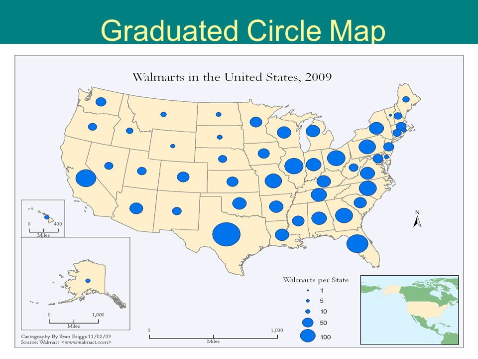
- Types:
- graduated circle
- size of circle conveys quantitative statistic
- Example
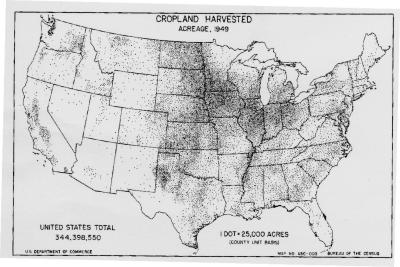
- dot
- display pattern, distribution, dispersion of data in an area
- Example
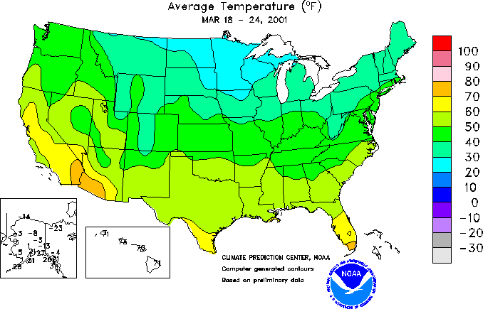
- choropleth
- display an average value of data in an area
- Example
- graduated circle
- reference maps
- Types of spatial patterns represented on maps include absolute and relative distance and direction, clustering, dispersal, and elevation.
- maps are a special form of model that depicts information in two dimensions and usually on paper. A model is a simplified generalization of something in real life
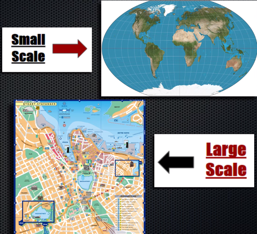
- relative distance (scale)
- Scale: The ratio between the size of an area on a map and he actual size of that same area on the earth’s surface
- Scale gives a frame of reference
- Representation Factor (RF):
- 1 inch : 250,000 feet
- Verbal:
- One inch represents 250,000 feet
- Visual
- |——————|——————| 0 250,000’ 500,000'
- direction
- absolute direction:
- north south, compass
- relative direction:
- left right, forward backwards, up down
- based on perspective in certain location
- absolute direction:
- clustering + dispersal
- where groups are (not) centered around
- density vs concentration:
- Density is the amount of an object within a certain area
- concentration is how these objects are distributed.
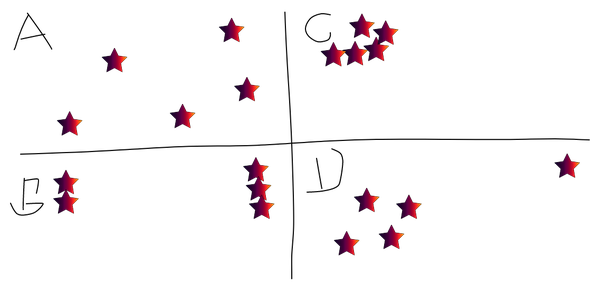
- Box A the distribution is dispersed.
- There is a clear cluster of stars in the upper left corner for Box C.
- Box B has concentrations in the left and right sides
- Box D has a cluster (though not as clustered as C) in the middle left and one outlier.
- elevation
- Hight from set point, typically water level
- All maps are selective in information; map projections inevitably distort spatial relationships in shape, area, distance, and direction
- Maps are 1D representations (projection) of a 2D environment, so they’ll inherently have distortion
- Mercator
- shape: fairly accurate
- area: distorts area near north and south pole
- direction: turns curves into straight lines
- Goode’s
- shape: accurate
- area: accurate
- direction: accurate
- hard to understand
- Goode’s
- shape: everything slightly distorted outwards from 0’ 0'
- area: accurate
- direction: accurate
- Types of maps include reference maps and thematic maps
1.2 Geographic Data #
IMP 1B Geographers use maps and data to depict relationships of time, space, and scale.
- Learning Objective: Identify different methods of geographic data collection.
- Essential Knowledge:
- Data may be gathered in the field by organizations or by individuals.
- Geospatial technologies include geographic information systems (GIS), satellite navigation systems, remote sensing, and online mapping and visualization.
- Remote sensing:
- Record area from a distance
- People have used cameras with airplanes, kites, hot-air balloons, etc. for many years
- Nowadays use satellites
- Useful for any area that would be otherwise be difficult to travel record
- geographic information systems (GIS)
- merge mapping software with a database to overlay various data layers on a basic map grid
- Remote sensing:
- Spatial information can come from written accounts in the form of field observations, media reports, travel narratives, policy documents, personal interviews, landscape analysis, and photographic interpretation.
1.3 The Power of Geographic Data #
IMP 1C Geographers use maps and data to depict relationships of time, space, and scale.
- Learning Objective: Explain the geographical effects of decisions made using geographical information.
- Essential Knowledge:
- Geospatial and geographical data, including data and satellite imagery, are used at all scales for personal, business and organizational, and governmental decision making purposes.
- Used to measure
- climate change
- pollution
- spreads of fires
- military survalliance
- google maps / personal GPS
- delivering your packages
- Used to measure
- Geospatial and geographical data, including data and satellite imagery, are used at all scales for personal, business and organizational, and governmental decision making purposes.
1.4 Spatial Concepts #
PSO-1 Geographers analyze relationships among and between places to reveal important spatial patterns.
- Learning Objective: Define major geographic concepts that illustrate spatial relationships.
- Essential Knowledge:
- Spatial concepts include absolute and relative location, space, place, flows, distance decay, time-space compression, and pattern.
- location + place (same thing)
- actual position on earth
- space
- area that is occupied by something
- can refer to physical and cultural objects on the surface of earth
- relative space is concerned with where something is in relation to something else and changes constantly as interrelationships between people, places, and things change
- absolute space is a measurable area with definite boundaries
- site
- physical location of a place
- situation
- location of a place based on its relation to other places
- flows + patterns
- trends of relationships(?)
- distance decay
- The declining degree of acceptance of an idea or innovation with increasing time and distance from its point of origin or source.
- Example: The number of phone calls made decreases with distance.
- Greater number of migrants settled at the edge of the country closer to the country of origin, compared to the number settled on the opposite edge of the country.
- The diminishing evidence of cultural traits by a group of people, if the explanation clearly shows a link to the fact that due to migration there is less contact between the migrants and their home country.
- Explanatory factor behind distance decay relationship (e.g., travel cost, information availability).
- time-space compression (decrease in friction of distance)
- the increasing sense of connectivity that seems to be bringing people closer together even thought their distances are the same.
- Space time compression is the solution to distance decay because technology (internet,cell phones) is allowing us to communicate more across longer distances.

- location + place (same thing)
- Spatial concepts include absolute and relative location, space, place, flows, distance decay, time-space compression, and pattern.
1.5 Human–Environmental Interaction #
PSO-1 Geographers analyze relationships among and between places to reveal important spatial patterns.
- Learning Objective: Explain how major geographic concepts illustrate spatial relationships
- Essential Knowledge:
- Concepts of nature and society include sustainability, natural resources, and land use.
- sustainability
- the use of the earths renewable and nonrenewable natural resources in ways that ensure resource availability in the future
- 3 Pillars
- Environmental
- Having Conservation, Nonrenewable and renewable resources and Preservation
- Social
- Humans need shelter food and clothing to survive so make resources meet those needs
- Economic
- Having natural resources; supply and demand
- Environmental
- Humans take resources that aren’t always needed or they take advantage of the resources that we have. But there is a lot of supply and demand and humans don’t know how to balance the resources.
- natural resources
- Resources that come directly from Earth
- Need to be used in moderation if they aren’t renewable
- land use
- to be sustainable, land has to be used efficiently to get enough value but not worked too hard to the point where it looses nutrients
- sustainability
- Theories regarding the interaction of the natural environment with human societies have evolved from environmental determinism to possibilism.
- Environmental determinism : The idea that physical environment caused social development
- Possibilism: (Replaces Environmental Determinism) The idea that environment may limit some human actions, but people have the ability to adapt to their environment
- Concepts of nature and society include sustainability, natural resources, and land use.
1.6 Scales of Analysis #
PSO-1 Geographers analyze relationships among and between places to reveal important spatial patterns.
- Learning Objective: Define scales of analysis used by geographers.
- Essential Knowledge:
- Scales of analysis is how information is clustered
- global — worldwide
- regional — groups of states, e.g. North America
- national — single state, e.g. Wisconsin
- local — city or town, e.g. Middleton
- Scale is what infomation is shown
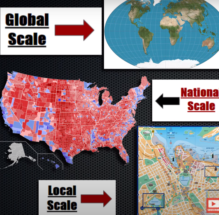
- Scales of analysis is how information is clustered
- Learning Objective: Explain what scales of analysis reveal.
- Essential Knowledge:
- Patterns and processes at different scales reveal variations in, and different interpretations of, data.
- To understand individual, local, regional, national, and global interrelationships, geographers compare and contrasts different scale views.
- Downsides to large scale
- Patterns and processes at different scales reveal variations in, and different interpretations of, data.
1.7 Regional Analysis #
SPS 1 Geographers analyze complex issues and relationships with a distinctively spatial perspective
- Learning Objective: Describe different ways that geographers define regions.
- Essential Knowledge:
- Regions are defined on the basis of one or more unifying characteristics or on patterns of activity.
- A region is an area characterized by similarity or by cohesiveness that sets it apart from other areas.
- Regions allow us to generalize about a common characteristic so we can better group them
- A region is an area on the earth identified by two common characteristics: physical and political geography.
- Physical regions are features such as deserts, mountains, and lakes.
- Political regions by establishing political boundaries like the borders of countries.
- Some regions are based on culture (language or religion), while physical geography defines others.
- Types of regions include formal, functional, and perceptual/vernacular
- Formal (Uniform)
- Region with high level of consistency in a certain cultural or physical attribute
- E.g.
- Dairying region of North America
- Political boundaries
- Tropical Regions
- Functional (Nodal)
- A region with a node, sometimes a hearth, surrounded by interconnecting linkages.
- Usually connections relate to trade, communication, transportation, etc.
- E.g.
- Cell towers
- Newspaper Circulation
- School District
- Metropolitan Area
- Perceptual (Vernacular)
- A region defined by feelings and prejudices that may or may not be true.
- A construct of one’s mental map
- E.g.
- Bible belt
- South
- Formal (Uniform)
- Regional boundaries are transitional and often contested and overlapping.
- Regions of the world can and do overlap such as the areas of Southeast Asia and Asia. Regions also have transitional boundaries like between North Africa and Sub-Saharan Africa
- Geographers apply regional analysis at local, national, and global scales
- There is not total agreement, however, among geographers on how all regions are defined.
- One geographer may place Chad in the region of North Africa, and another would classify Chad as part of Central Africa.
- Geographers will also use two different terms to describe the same area; the Middle East and Southwest Asia, for example.
- There is not total agreement, however, among geographers on how all regions are defined.
- Regions are defined on the basis of one or more unifying characteristics or on patterns of activity.
👣 Unit 2 — Population and Migration Patterns and Processes #
Developing Understanding
This unit addresses the patterns associated with human populations. Populations may increase or decrease as a result of a combination of natural changes (births and deaths) and migration patterns (emigration and immigration). Students examine population distributions at different scales—local, national, regional, and global. Population pyramids demonstrate age-sex structures, revealing the growth or decline of generations and allowing geographers to predict economic needs based on reproductive and aging patterns. Students learn about factors that influence changes in population as well as the long- and short-term effects of those population changes on a place’s economy, culture, and politics. For example, environmental degradation and natural hazards may prompt population redistribution at various scales, which in turn creates new pressures on the environment and on cultural, economic, and political institutions. The study of migration patterns allows students to examine factors contributing to voluntary and forced relocation and the impact of these migrating populations on existing settlements. Combined, the concepts and theories encountered in this unit help students develop connections and transfer their learning in upcoming units to course topics such as cultural patterns, the political organization of space, food production issues, natural resource use, and urban systems.
BIG IDEA 1 Patterns and Spatial Organization (PSO)
- How does where and how people live impact global cultural, political, and economic patterns? BIG IDEA 2 Impacts and Interactions (IMP)
- How does the interplay of environmental, economic, cultural, and political factors influence changes in population? BIG IDEA 3 Spatial Processes and Societal Change (SPS)
- How do changes in population affect a place’s economy, culture, and politics?
2.1 Population Distribution #
PSO-1 Understanding where and how people live is essential to understanding global cultural, political, and economic patterns.
- Learning Objective: Identify the factors that influence the distribution of human populations at different scales.
- Essential Knowledge:
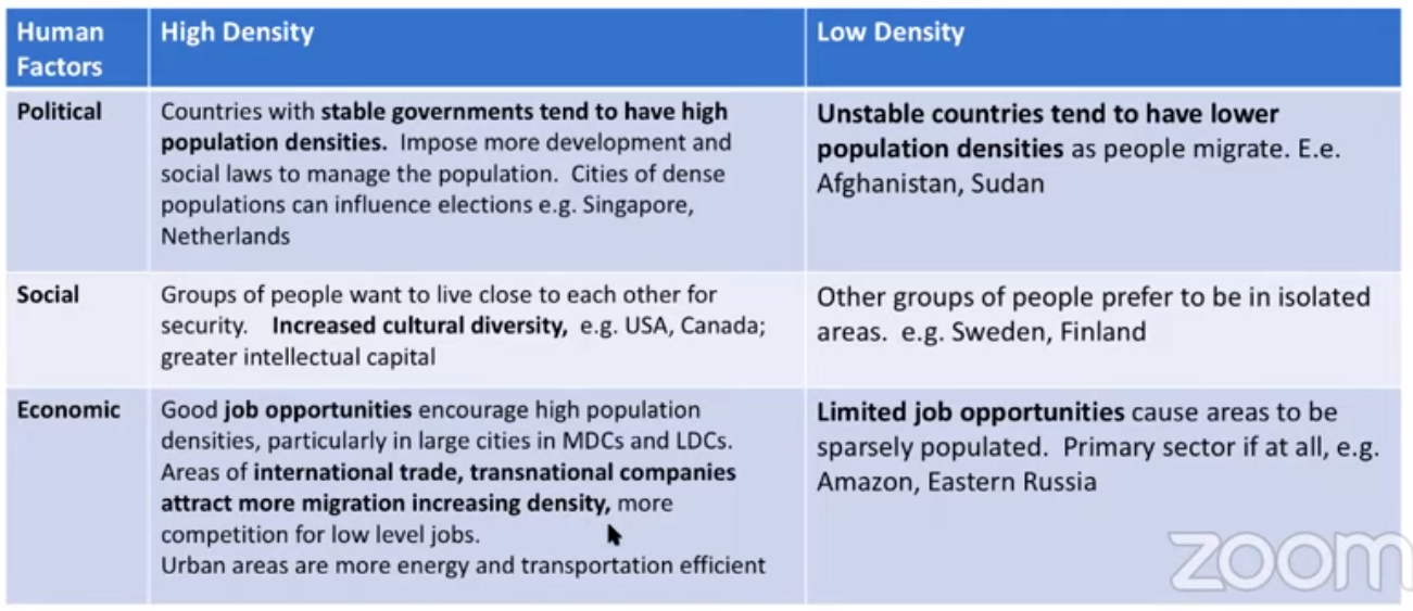
- Physical factors (e.g., climate, landforms, water bodies) and human factors (e.g., culture, economics, history, politics) influence the distribution of population.
- physical:
- humans avoid areas that are
- dry
- too dry to plant food
- lack water for crops + regular consumption
- wet + hot
- combination of rain and heat deplete nutrients from soil
- typically near equator
- cold + high altitude
- to rough for easy transportation
- to cold for crops
- dry
- places considered too harsh for occupancy have diminished over time
- people like to go to low-lying areas with fertile soil and temperate climate
- near a river or ocean is good too
- humans avoid areas that are
- cultural:
- economics
- history
- politics
- physical:
- Factors that illustrate patterns of population distribution vary according to the scale of analysis.
- Scale of analysis is the level of detail that a map goes into
- Demography: study of characteristics of human population, varies according to scale
- 75% of population live on 5% of land
- 50% of population live in urban areas
- Land inhabited called ecumene
- most extreme cases occur at small scales
- countries vary in size so aren’t great for seeing details, but they’re better than state
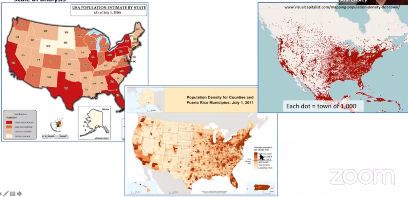
- countries vary in size so aren’t great for seeing details, but they’re better than state
- Physical factors (e.g., climate, landforms, water bodies) and human factors (e.g., culture, economics, history, politics) influence the distribution of population.
- Learning Objective: Define methods geographers use to calculate population density.
- Essential Knowledge:
- The three methods for calculating population density are arithmetic, physiological, and agricultural.
- Artihmetic / crude - all people / all land
- Physiological - all people / agricultural land
- Agricultural - all farmers / agricultural land
- The three methods for calculating population density are arithmetic, physiological, and agricultural.
- Learning Objective: Explain the differences between and the impact of methods used to calculate population density.
- Essential Knowledge:
- The method used to calculate population density reveals different information about the pressure the population exerts on the land.
- High agricultural density implies that farmers aren’t extracting the most value from there land (better farmers need less farmers to fully use there land)
- Low agricultural density implies farmers are very efficient and probably developed
- High physiological density implies that there is either little farmland or that agricultural land is being used by more and may reach its output limit sooner than a country that has a lower density
- High arithmetic density implies there are a lot of people in a small area, aka urbanization
- The method used to calculate population density reveals different information about the pressure the population exerts on the land.
2.2 Consequences of Population Distribution #
PSO-2 Understanding where and how people live is essential to understanding global cultural, political, and economic patterns.
- Learning Objective: Explain how population distribution and density affect society and the environment.
- Essential Knowledge:
- Population distribution and density affects political, economic, and social processes, including the provision of services such as medical care.
- redistricting / gerrymandering
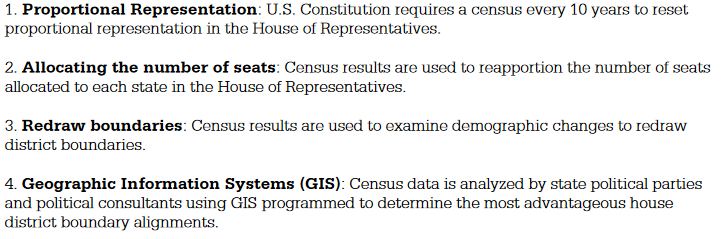
- Results
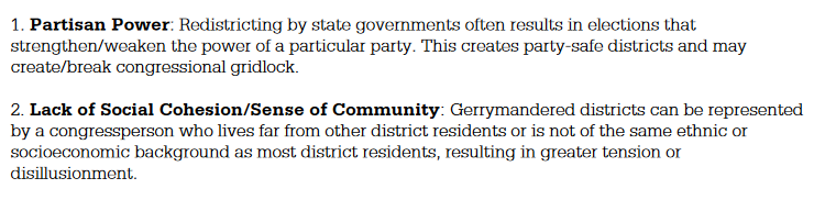
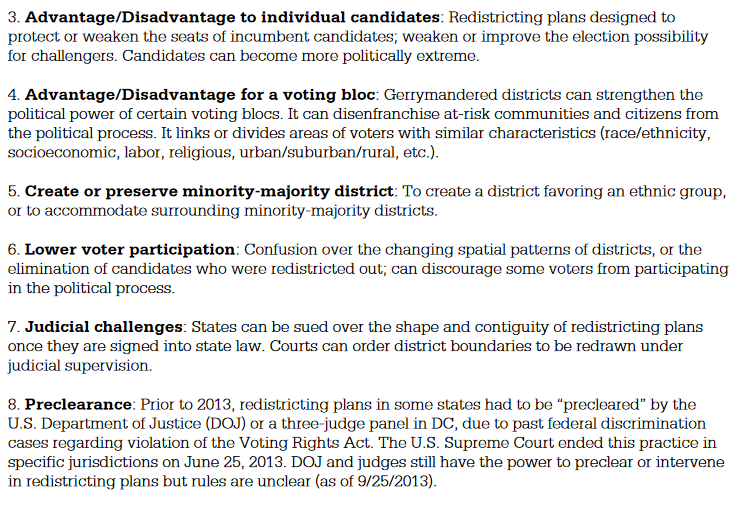
- Results
- provision of services such as medical care
- those closer to medical services are more likely be able to use them
- redistricting / gerrymandering
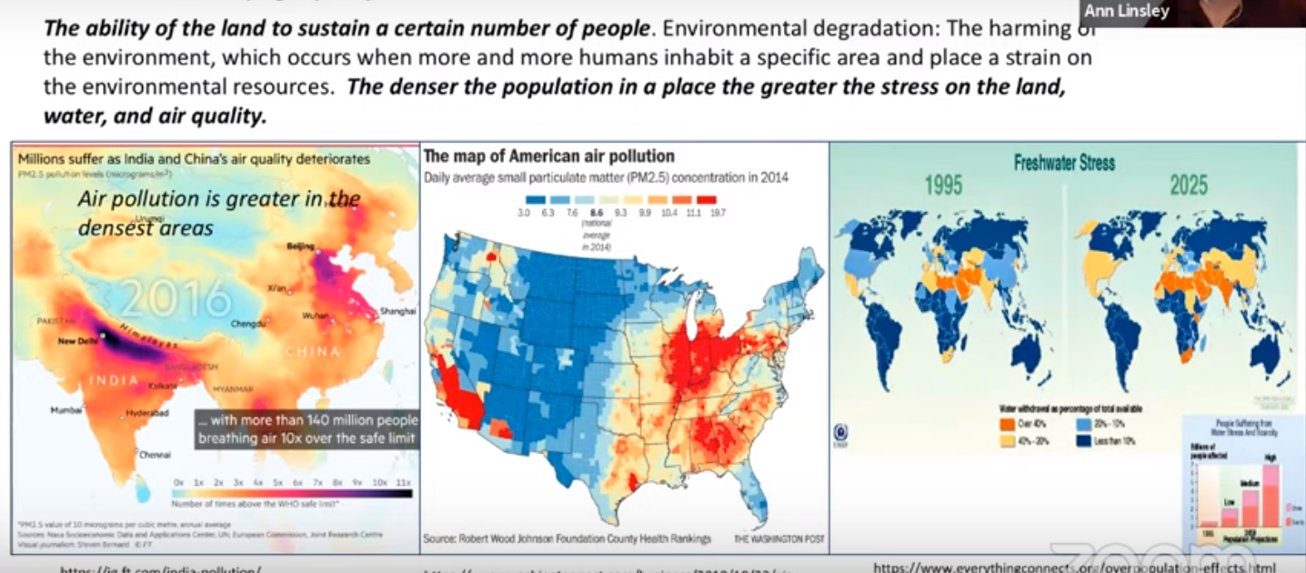
- Population distribution and density affect the environment and natural resources; this is known as carrying capacity
- carrying capacity — how many people an area can support on a sustained basis
- sustainability
- Population distribution and density affects political, economic, and social processes, including the provision of services such as medical care.
2.3 Population Composition #
PSO-2 Understanding where and how people live is essential to understanding global cultural, political, and economic patterns.
- Learning Objective: Describe elements of population composition used by geographers.
- Essential Knowledge:
- Patterns of age structure and sex ratio vary across different regions and may be mapped and analyzed at different scales
- most extreme cases occur at small scales
- countries vary in size so aren’t great for seeing details, but they’re better than state
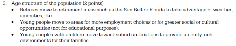
- age structure
- older in retirement areas
- younger in military / college towns
- helps predict how much money is needed for social services
- old and young (dependent) require more money to support
- sex ratio
- more male in military training camps
- Learning Objective: Explain ways that geographers depict and analyze population composition.
- Essential Knowledge:
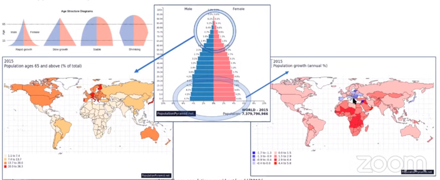
- Population pyramids are used to assess population growth and decline and to predict markets for goods and services.
- a representation of a country’s population displayed by age and gender groups on a bar graph.
- Normally shows the % of the total pop in 5-year age brackets with youngest at base of pyramid and oldest at the top.
- The length of the bar represents the % of total pop in that group.
- Males on left, females on right.
- Young population (bulge at bottom)
- Economic Risks
- Potential for job shortage
- Shift in workforce and jobs that target young people
- Social
- Increasing demand on support for youth
- Preschools, parks, etc.
- Health and Education
- Have to be prepared for childhood diseases
- Increase spending on family planning programs
- Middle (bulge in middle)
- Economic:
- Not enough upcoming workers
- Possible automation
- People work longer (later retirement)
- Economic:
- Economic Risks
- Aging population (bulge at top)
- Economic
- Transition to tertiary jobs
- Income tax burden falls on a shrinking workforce
- Over 65 expect long term expensive healthcare
- Strain on pension system with fewer paying in
- Capital flow from aging countries shifting global economic power
- Social Risks
- Migration needed to satisfy labor needs
- Migration needed to satisfy labor needs
- Economic
- Population pyramids are used to assess population growth and decline and to predict markets for goods and services.
2.4 Population Dynamics #
IMP-2 Changes in population are due to mortality, fertility, and migration, which are influenced by the interplay of environmental, economic, cultural, and political factors.
- Learning Objective: Explain factors that account for contemporary and historical trends in population growth and decline.
- Essential Knowledge:
- Demographic factors that determine a population’s growth and decline are fertility, mortality, and migration.
- fertility
- crude birth rate (CBR) — total live births in a year for every 1,000 people alive in society
- infant mortality rate (IMR) — annual number of deaths of infants under 1 year of age compared with number of live births
- Decrease due to (life expectancy too)
- Decrease due to (life expectancy too)
- total fertility rate (TFR) — average number of children a woman will have throughout her childbearing years (15-49)
- mortality
- crude death rate (CDR) — total number of deaths in a year for every 1,000 people alive in society
- life expectancy — number of years expected for a newborn to live
- migration
- fertility
- Geographers use the rate of natural increase and population-doubling time to explain population growth and decline.
- Natural increase rate (NIR) — Percentage by which a population grows in a year
- CBR - CDR = NIR
- CBR - CDR = NIR
- Doubling Time — Number of years needed to double the population (assuming a steady rate of growth), is affected by NIR
- Natural increase rate (NIR) — Percentage by which a population grows in a year
- Social, cultural, political, and economic factors influence fertility, mortality, and migration rates.
- Social + cultural
- norms
- when to get married
- role of genders
- norms
- political
- laws
- anti/pro abortion
- one child policy (China)
- laws
- Social + cultural
- Demographic factors that determine a population’s growth and decline are fertility, mortality, and migration.
2.5 The Demographic Transition Model #
IMP-2 Changes in population are due to mortality, fertility, and migration, which are influenced by the interplay of environmental, economic, cultural, and political factors.
- Learning Objective: Explain theories of population growth and decline.
- Essential Knowledge:
- The demographic transition model can be used to explain population change over time.
- explains the rising and falling of NIR over time in a country
- no country has ever reverted back to a previous stage
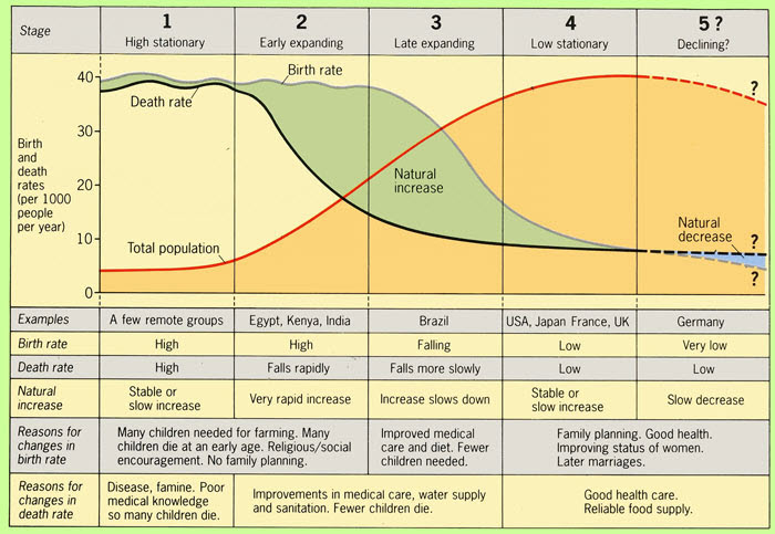
- Stage 1: Hunter-gatherers, scarcity of food
- Stage 2: Increase in healthcare, still lots of kids
- Stage 3: Rural to urban, less kids (due to less space / resources in urban area)
- Stage 4: Developed, stuff balances out
- Stage 5: Replacement rate isn’t enough to sustain population
- Reasons for population drop off / decrease
- Reasons for population drop off / decrease
- The epidemiological transition explains causes of changing death rates.
- stage 1 — prestillence and famine (high CDR):
- principal cause of death: infectious and parasitic diseases
- stage 2 — receding pandemic (rapidly declining CDR)
- factors such as improved sanitation, nutrition, and medicine
- stage 3 — degenerative disease (moderately declining CDR)
- decrease in deaths by infectious diseases, increase in deaths by chronic disorders associated with aging
- stage 4 — delayed degenerative diseases (low but increasing CDR)
- death by cardiovascular diseases and cancer delayed because of modern medicine
- (possible) stage 5
- evolution: infectious disease microbes adapt around drugs, new strains form
- poverty: infectious diseases are more prevalent in poor areas due to unsanitary conditions and inability to afford medicine / treatment
- increased connections: advancements in transportation, e.g. air travel, increases contact as well as urbanization
- death rates are high during first, the drop off til they level around stage 4
- this is due to increase in education and healthcare, as well as contraceptives
- stage 1 — prestillence and famine (high CDR):
- Jobs
- Economic Activities
- Primary: Production of raw materials or natural resource extraction (e.g., agriculture, mining, energy, timber, fishing)
- Secondary: Processing or refining of natural resources (e.g., manufacturing finished goods, industry, building construction, assembly, factory work, value-added, blue collar)
- Tertiary: Provision of services (e.g., healthcare, technology, communications, financial, wholesale and retail trade, transportation, personal, professional, business services, white collar)
- How these patterns change as courtiers develop
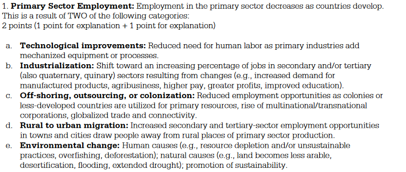
- Economic Activities
- The demographic transition model can be used to explain population change over time.
2.6 Malthusian Theory #
IMP-2 Changes in population are due to mortality, fertility, and migration, which are influenced by the interplay of environmental, economic, cultural, and political factors.
- Learning Objective: Explain theories of population growth and decline.
- Essential Knowledge:
- Malthusian theory and its critiques are used to analyze population change and its consequences.
- Thomas Malthus - proposed in his Essay on the Principle of Population 1798, that the population grows faster than the food supply. He claimed that while population expanded at a geometric or exponential rate, food supply increased arithmetically or linearly.
- However, the continued evolution of agriculture has continued to provide the world with an adequate amount of food. The problem now is distribution of food, not the actual production of it. Also, the birth rates declined sharply in the latter part of the 20th century, thus the world population expanded to only 6 billion compared to Malthus’s predicted 10.
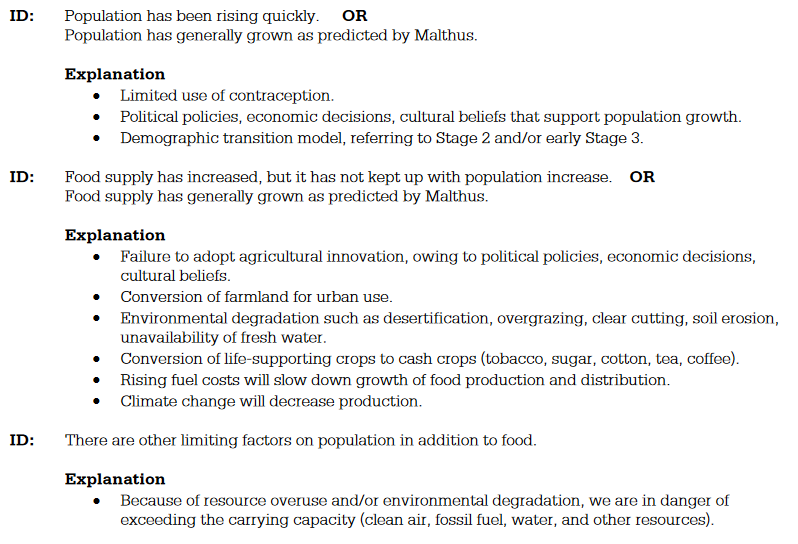
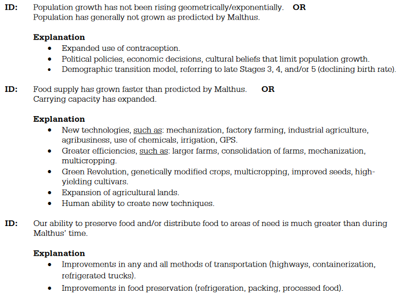
- Neo-Malthusians
- claim that more LDC’s are in stage 2 of the demographic transition than ever before in history, thus putting a larger strain on the food supply. They also modified Malthus’s theory by stating that the population growth is out-stripping not just food production, but a wide variety of resources, such as oil, natural gas, etc.
- Critics of Malthus
- claim that population growth stimulates new technology and that as strain is put on any resource, the inventive human being will simply develop an alternative method once it is economically feasible.
- Malthusian theory and its critiques are used to analyze population change and its consequences.
2.7 Population Policies #
SPS-2 Changes in population have long- and short-term effects on a place’s economy, culture, and politics.
- Learning Objective: Explain the intent and effects of various population and immigration policies on population size and composition.
- Essential Knowledge:
- Types of population policies include those that promote or discourage population growth, such as pronatalist, antinatalist, and immigration policies.
- countries fearing overpopulation may enact Antinatilist policies, e.g. China’s child limit
- countries fearing dipping below the replacement level, to assure the population continues to replace itself, may enact pronatilist policies, e.g. Scandinavian country’s proactive ads, or policy encourage immigration (migration in to the country)
- Types of population policies include those that promote or discourage population growth, such as pronatalist, antinatalist, and immigration policies.
2.8 Women and Demographic Change #
SPS-2 Changes in population have long- and short-term effects on a place’s economy, culture, and politics.
- Learning Objective: Explain how the changing role of females has demographic consequences in different parts of the world.
- Essential Knowledge:
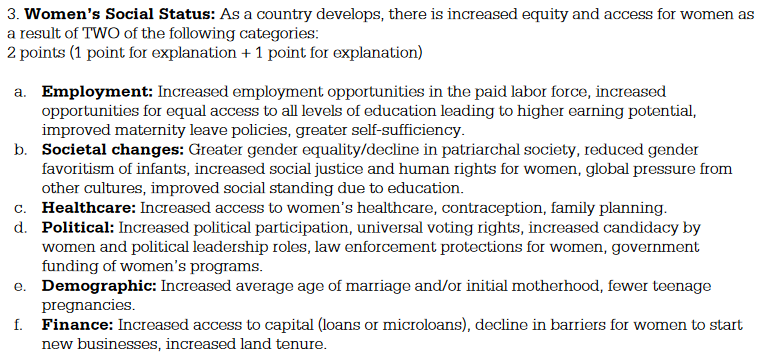
- Changing social values and access to education, employment, health care, and contraception have reduced fertility rates in most parts of the world.
- social:
- women have a say in whether or not they want a child
- economic:
- women joining the workforce leaves less time for relationships
- political roles:
- women in government can enact laws that better represent what women may need
- healthcare:
- higher chance of mother and child surviving
- contraception
- less likely for ‘accidents’
- Social status change
- social:
- Changing social, economic, and political roles for females have influenced patterns of fertility, mortality, and migration, as illustrated by Ravenstein’s laws of migration.
- Ravenstein’s Laws:
- Most migrants move only a short distance.
- Migration proceeds step by step. There is a process of absorption, whereby people immediately surrounding a rapidly growing town move into it and the gaps they leave are filled by migrants from more distant areas, and so on until the attractive force is spent.
- Migrants going long distances generally go by preference to one of the great centres of commerce or industry.
- Each current of migration produces a compensating counter-current.
- Natives of towns are less migratory than those of rural areas
- Females are more migratory than males within the kingdom of their birth, but males more frequently venture beyond.
- Most migrants are adults: families rarely migrate out of their country of birth.
- Large towns grow more by migration than by natural increase.
- Migration increases in volume as industries and commerce develop and transport improves.
- The major direction of migration is from the agricultural areas to the centres of industry and commerce.
- The major causes of migration are economic.
- Ravensteins laws aren’t scientific
- Are too specificied
- E.g. short distance occurs in Africa where most migrations is due to wars, while most migration from China is to the US (long)
- Ravenstein’s Laws:
- Changing social values and access to education, employment, health care, and contraception have reduced fertility rates in most parts of the world.
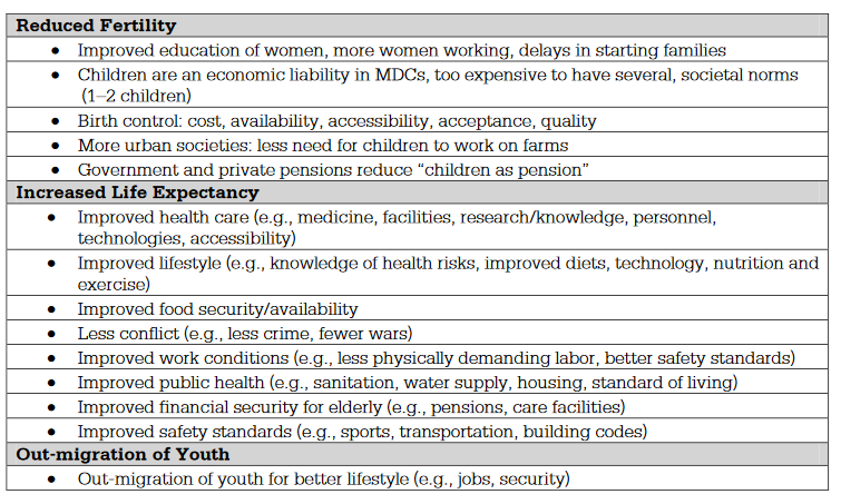
2.9 Aging Populations #
SPS-2 Changes in population have long- and short-term effects on a place’s economy, culture, and politics.
- Learning Objective: Explain the causes and consequences of an aging population.
- Essential Knowledge:
- Population aging is determined by birth and death rates and life expectancy.
- An aging population has political, social, and economic consequences, including the dependency ratio.
- dependency ratio: ratio of citizens under 15 or 65 and older to those between age 15 and 65
- Gives us an idea of how many workers are needed to support the dependent population
- If the population is aging:
- Government spending for adult daycare, nursing homes, and home care social services will increase
- Government spending for education, child welfare, and health services will decrease
- Why population is aging
- Reduced Fertility
- Improved education of women, more women working, delays in starting families
- Children are an economic liability in MDCs, too expensive to have several, societal norms (1–2 children)
- Birth control: cost, availability, accessibility, acceptance, quality
- More urban societies: less need for children to work on farms
- Government and private pensions reduce “children as pension”
- Increased Life Expectancy
- Improved health care (e.g., medicine, facilities, research/knowledge, personnel, technologies, accessibility)
- Improved lifestyle (e.g., knowledge of health risks, improved diets, technology, nutrition and exercise)
- Improved food security/availability
- Less conflict (e.g., less crime, fewer wars)
- Improved work conditions (e.g., less physically demanding labor, better safety standards)
- Improved public health (e.g., sanitation, water supply, housing, standard of living)
- Improved financial security for elderly (e.g., pensions, care facilities)
- Improved safety standards (e.g., sports, transportation, building codes)
- Out-migration of Youth
- Out-migration of youth for better lifestyle (e.g., jobs, security)
- Out-migration of youth for better lifestyle (e.g., jobs, security)
- Reduced Fertility
- dependency ratio: ratio of citizens under 15 or 65 and older to those between age 15 and 65
2.1 Causes of Migration #
IMP-2 Changes in population are due to mortality, fertility, and migration, which are influenced by the interplay of environmental, economic, cultural, and political factors.
- Learning Objective: Explain how different causal factors encourage migration.
- Essential Knowledge:
- Migration is commonly divided into push factors and pull factors.
- push factors — bad stuff in current location
- famine
- war
- no jobs
- disease
- violence
- hate crime
- overcrowding
- pull factors — good stuff somewhere else
- better jobs
- lower taxes
- better climate
- better schools/social services
- more room
- low crime
- push factors — bad stuff in current location
- Push/pull factors and intervening opportunities/obstacles can be cultural, demographic, economic, environmental, or political.
- Intervening obstacle — a feature that hinders migration
- cultural
- similar culture to home
- demographic
- people tend to like to be around similar people (age, race)
- economic
- better jobs
- environmental
- distance
- Distance Decay: Says that migrants try to minimize the friction of distance
- migrants will be more inclined to move to locations closer to them; they will be less interested in moving longer distances
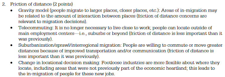
- has been on the decline
- migrants will be more inclined to move to locations closer to them; they will be less interested in moving longer distances
- Intervening Opportunity’s: Idea that migrants will choose a location closer rather than farther if all other factors are the same
- related to other reasons (time and money go up farther you have to travel)
- Distance Decay: Says that migrants try to minimize the friction of distance
- climate (push + pull)
- oceans/water
- rugged terrain (intervening obstacles)
- distance
- political
- social services
- no war
- less corruption
- age
- Migration is commonly divided into push factors and pull factors.
2.1 Forced and Voluntary Migration #
IMP-2 Changes in population are due to mortality, fertility, and migration, which are influenced by the interplay of environmental, economic, cultural, and political factors.
- Learning Objective: Describe types of forced and voluntary migration.
- Essential Knowledge:
- Forced migrations include slavery and events that produce refugees, internally displaced persons, and asylum seekers
- types of migration:
- Immigrant:
- person entering another country with intention of living there
- Emigrant:
- person who is leaving one country with the intention of living in a different country
- refugee:
- A person who flees, is displaced, or is forced to leave his or her home country, often due to religion, ethnicity, race, or political belief
- Reasons
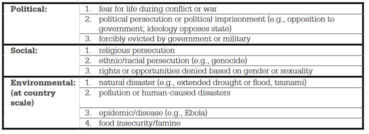
- IDP — Internally Displaced Person:
- A person who is forced out of the home region due to war, political, or social unrest, environmental problems, etc.
- does not cross any international boarders
- Immigrant:
- types of migration:
- Types of voluntary migrations include transnational, transhumance, internal, chain, step, guest worker, and rural-to-urban.
- transnational
- migration across one or more nation
- transhumance
- movement between mountains and lowlands, typically practiced by farmers
- Cyclic Movement: movement that has a closed route repeated annually or seasonally
- internal
- permanent move w/in the same country.
- Interregional migration
- move from one region to another within country.
- e.g. from Middleton to North WI boonies
- Intraregional migration
- move within one region within one country.
- e.g. moving apartments in downtown Madison
- chain migration
- migration of people to a certain location because family members (or other contacts), typically of the same nationality, previously migrated there
- Examples must clearly establish a link/transfer of knowledge between the first group of migrants and subsequent groups OR it should be clear that subsequent migrants are from areas of close proximity to the source area of the early migrants, and that they are migrating to the same destination area.
- step
- migration to a distant destination that occurs in stages
- hard to measure / verify
- e.g. from farm to nearby village to town to city
- guest worker
- legal immigrant who has work visa, usually short term
- typically take unskilled labor jobs
- risk of them overstaying
- typically citizens of poor countries who temporarily obtain dangerous low-paying jobs in MDC’s that the permanent citizens refuse to accept.
- rural-to-urban
- migration flow going frow rural to urban areas
- In LDC’s, the migration trend recently has been rural to urban.
- In MDC’s, the migration trend has been urban to suburban
- Counterurbanization — net migration from urban to rural areas.
- This has been a trend in MDC’s, as improved technologies enable people to live farther from their places of employment and still enjoy all the amenities the city offers.
- However, in the U.S., counterurbanization has stopped because of poor economic conditions in the rural areas.
- Once again, the trend is from non-metropolitan to metropolitan areas, only now it is characterized by a move into the suburbs rather than the inner city.
- transnational
- Forced migrations include slavery and events that produce refugees, internally displaced persons, and asylum seekers
2.1 Effects of Migration #
IMP-2 Changes in population are due to mortality, fertility, and migration, which are influenced by the interplay of environmental, economic, cultural, and political factors.
- Learning Objective: Explain historical and contemporary geographic effects of migration.
- Essential Knowledge:
- Migration has political, economic, and cultural effects.
- cultural
- visually see change in landscape
- Chinatown, mosques, etc.
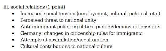
- political
- potentially controversial
- hate crimes
- economic
- typically beneficial
- fill unskilled labor jobs
- Migration transition
- identified by Wilbur Zelinsky
- consists of changes in a society comparable to the demographic transition.
- Stage 1 consists of little migration
- Stage 2 involves international migration
- Stages 3 and 4 are characterized by internal migration.
- brain drain may occur due to human capital theory of migration (states that smart people are the ones to leave and seek better job opportunities)
- smartest/most talented people leave a country, leaving only stupid people
- benefitial to both countries
- in-country gets talented labor and capital
- out-country gets often gets remittances (payments sent from individuals)
- Quotas — maximum limits on the number of people who could immigrate to the U.S. from a country in 1 year — may encourage illegal immigrants
- some countries rely on immigration from other countries to
- stay above the replacement level of 2.1 to assure the population stays even
- support those who are dependent (under 15, over 65)
- cultural
- Migration has political, economic, and cultural effects.
- Normally shows the % of the total pop in 5-year age brackets with youngest at base of pyramid and oldest at the top.
- The length of the bar represents the % of total pop in that group.
⚱️ Unit 3 - Cultural Patterns and Processes #
Developing Understanding
The main focus of this unit is on cultural patterns and processes that create recognized cultural identities. Students consider the physical environment to determine the effects of geographical location and available resources on cultural practices. Visuals representing artifacts, mentifacts and sociofacts all shed light on cultural landscapes and how they change over time. Practice in analyzing images of different places at different times for evidence of their ethnicity, language, religion, gender roles and attitudes, and other cultural attributes builds students’ understanding of cultural patterns and processes. This unit also considers from a temporal and spatial perspective how culture spreads, through traditional forces such as colonialism and imperialism and through contemporary influences such as social media. Rather than emphasize the details of cultural practices associated with specific languages and religions, this unit instead focuses on the distribution of cultural practices and on the causes and effects of their diffusion. For example, students might study the distribution of Chinese versus English languages or the diffusion patterns of religions such as Hinduism and Islam, at local, national, or global scales. An understanding of the diffusion of cultural practices provides a foundation for the study of political patterns and processes in the next unit
BIG IDEA 1 Patterns and Spatial Organization (PSO)
- How does where people live and what resources they have access to impact their cultural practices? BIG IDEA 2 Impacts and Interactions (IMP)
- How does the interaction of people contribute to the spread of cultural practices? BIG IDEA 3 Spatial Processes and Societal Change (SPS)
- How and why do cultural ideas, practices, and innovations change or disappear over time?
3.1 Introduction to Culture #
PSO-3 Cultural practices vary across geographical locations because of physical geography and available resources.
- Learning Objective: Define the characteristics, attitudes, and traits that influence geographers when they study culture.
- Essential Knowledge:
- Culture comprises the shared practices, technologies, attitudes, and behaviors transmitted by a society.
- shared practices
- teaching style
- events
- holidays
- technologies
- what side of the road we drive on
- 120/240 volt outlet
- attitudes
- how we treat different genders
- behaviors
- how we greet one another
- Social customs
- originates at a hearth, a center of innovation.
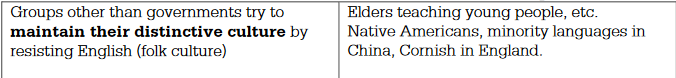
- Folk customs tend to have anonymous sources, from unknown dates, through multiple hearths
- Folk music tells stories or conveys information about daily activities.
- Isolation promotes cultural diversity as a group’s unique customs develop over several centuries.
- Therefore, folk culture varies widely from place to place at one time.
- Since most folk culture deals in some way with the lives and habits of its people, the physical environment in which the people act has a tremendous impact on the culture.
- pop culture generally has a known originator, normally from MDC’s, and results from more leisure time and more capital.
- Pop music is written by specific individuals for the purpose of being sold to a large number of people.
- shared practices
- Cultural traits include such things as food preferences, architecture, and land use.
- Food:
- the food we eat daily and the food we experience while traveling around the world all depends upon our location
- often passed throughout generations
- brings us together; sharable
- food in US reflects patterns of migration and what we’re capable of growing
- food also shows if there’s any (religious) taboos
- Low meat consumption in Africa and S Asia due to large Hindu population, which don’t eat beef because they believe the cow to be sacred
- Muslim and Judaism prohibited from eating pork
- Somali clans restrict the consumption of fish
- Land use:
- location determines what foods are grown locally and readily available in a particular region of the world
- certain states are known for certain foods; Jersey tomatoes, Florida oranges, Georgia peaches
- location determines what foods are grown locally and readily available in a particular region of the world
- Architectural trait
- reflection of our built land scape
- can explain what was going on at a given time and what resources were available
- Food:
- Cultural relativism and ethnocentrism are different attitudes toward cultural difference.
- relativism
- looking at culture objectively / holistically
- believing nothing is right or wrong
- ethnocentrism
- viewing other cultures through your own
- believing that your culture is the norm / superior
- pride in heritage, devaluation of other groups
- relativism
- Culture comprises the shared practices, technologies, attitudes, and behaviors transmitted by a society.
3.2 Cultural Landscapes #
PSO-3 Cultural practices vary across geographical locations because of physical geography and available resources.
- Learning Objective: Describe the characteristics of cultural landscapes.
- Essential Knowledge:
- Cultural landscapes are combinations physical features, agricultural and practices, religious and linguistic characteristics, evidence of sequent occupancy, and other expressions of culture including traditional and postmodern architecture and land-use patterns.
- Toponyms
- reflect leaders / people of power / religious figures / in immigrant’s native language
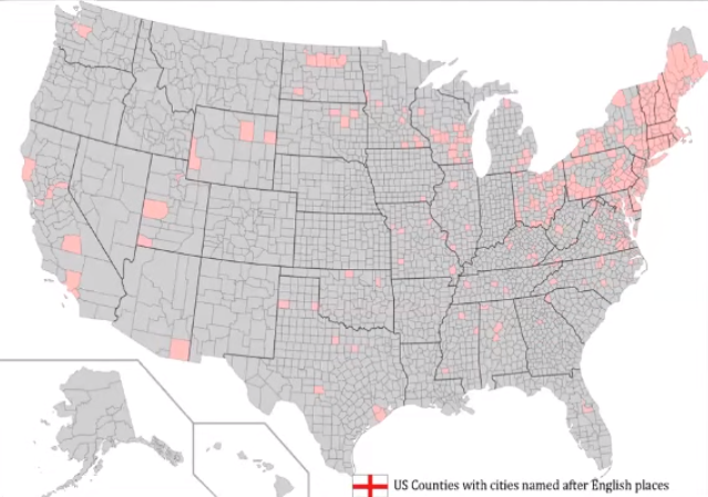
- reflect leaders / people of power / religious figures / in immigrant’s native language
- Religious impact
- Religious architecture
- sacred spaces
- religious symbols
- Architecture
- traditional architecture built for elements that impact the area being built on
- built with materials (abundantly) available
- post-modern architecture is designed to descriptive / feats of design
- Sequent Occupance
- early societies leave their cultural imprint on a place
- old fashion architecture
- old-street’s names
- land surveys — how land was parceled / divided
- square pattern system
- long-lot (french)
- housing
- reflects cultural identities of those who lived there and environmental constraints
“The cultural landscape is fashioned from a natural landscape by a cultural group. Culture is the agent, the natural area is the medium, the cultural landscape is the result.” - Carl Sauer
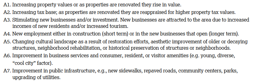
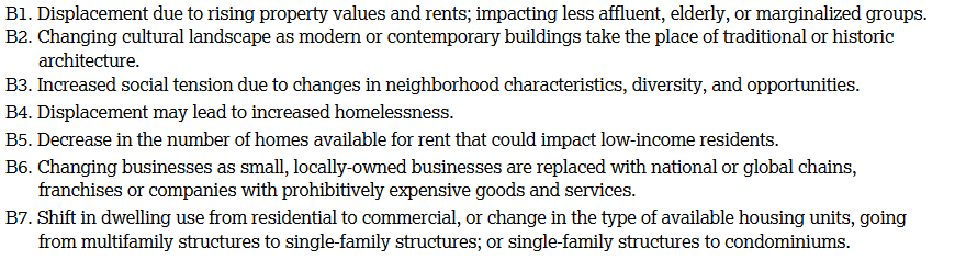
- Gentrification
- Positive Impacts
- Negative Impacts
- How govt can slow down + rpevent
- Positive Impacts
- Toponyms
- Cultural landscapes are combinations physical features, agricultural and practices, religious and linguistic characteristics, evidence of sequent occupancy, and other expressions of culture including traditional and postmodern architecture and land-use patterns.
- Learning Objective: Explain how landscape features and land and resource use reflect cultural beliefs and identities
- Essential Knowledge:
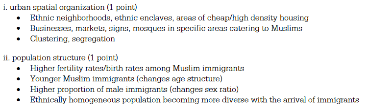
- Attitudes toward ethnicity and gender, including the role of women in the workforce; ethnic neighborhoods; and indigenous communities and lands help shape the use of space in a given society.
- positive attitudes encourage chain migration
- can lead to subsections of area with high concentration of a particular ethnicity
- China town
- little Mexico
- generally, women are becoming more equal but there’s still progress to be made
3.3 Cultural Patterns #
PSO-3 Cultural practices vary across geographical locations because of physical geography and available resources.
- Learning Objective: Cultural practices vary across geographical locations because of physical geography and available resources.
- Essential Knowledge:
- Regional patterns of language, religion, and ethnicity contribute to a sense of place, enhance placemaking, and shape the global cultural landscape.
- language
- dialects
- phrases
- ethnicity
- immigrants shape neighborhoods
- china town
- immigrants shape neighborhoods
- sense of place
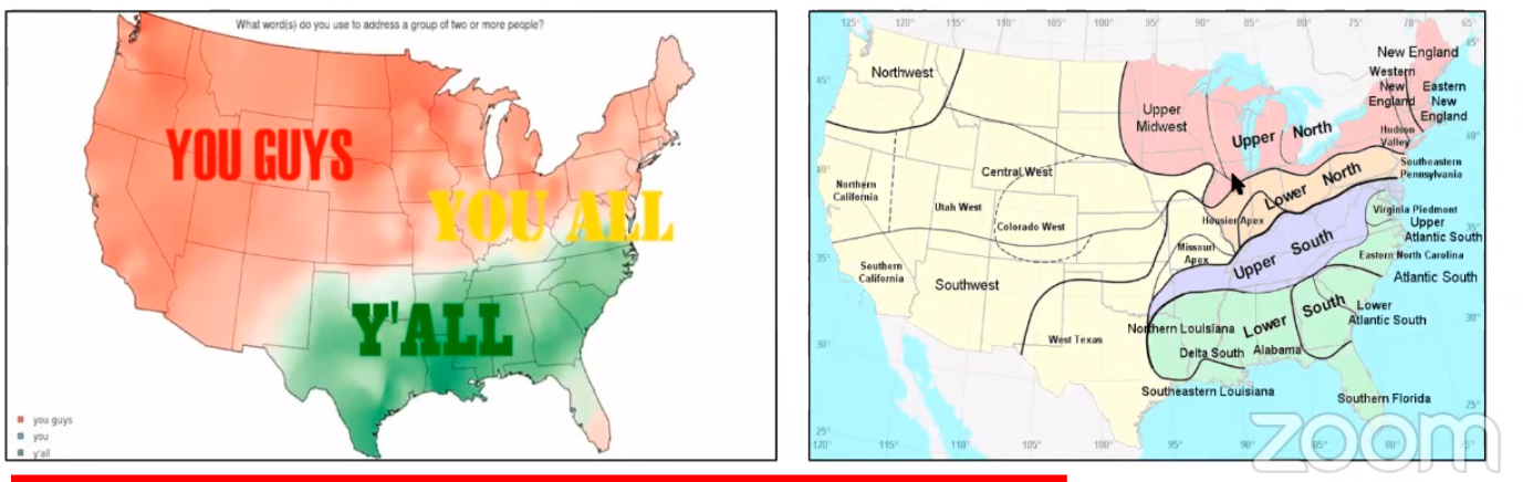
- Bilingualism
- language
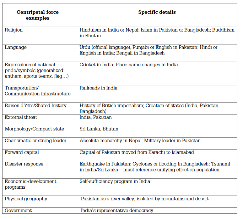
- Language, ethnicity, and religion are factors in creating centripetal and centrifugal forces.
- countries need a stronger centripetal force than centrifugal force to stay intact
- forces and produce regionalism or dissimilarity between people in the same country
- centripetal exist in a place and don’t move — typically people don’t wanna or can’t leave while push/pull are actively working
- centripetal forces — together
- Centripetal forces unify a state (provide stability, strengthen, bind together, create solidarity).
- culture
- regligious acceptance
- ethnic unity and tolerance
- social equity
- economic equity
- just and fair legal system
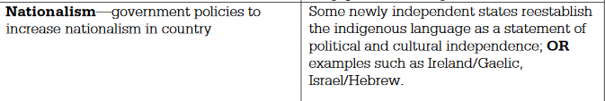
- nationalism
- history — common heritage

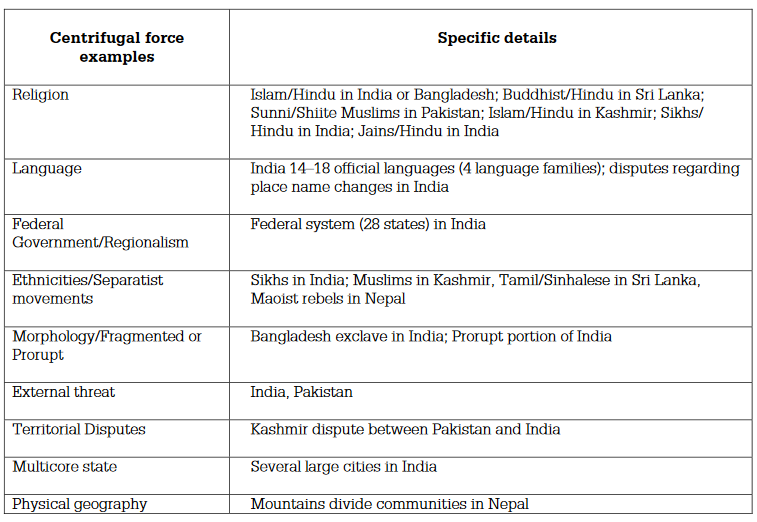
- centrifugal forces — apart (repel)
- Centrifugal forces divide a state (lead to balkanization/devolution, disrupt internal order, destabilize, weaken).
- cultural diversity
- religious differences
- language
- ethnic conflict
- social injustice
- nationalism
- legal restrictions
- physical features economic stratification
- “White flight” is the rapid fleeing of whites from the cities as black families emigrate out of the ghettos, or as the ghetto expands. It was encouraged by blockbusting.
- blockbusting- the real estate practice of scaring whites into selling their homes at low prices by telling them that blacks would soon be moving in and causing property values to fall. The real estate agents then turned around and sold the homes at extremely high prices to blacks that were emigrating from the inner city.
- Apartheid-the physical separation of different races into different geographic areas, i.e. South Africa.
- The apartheid laws were repealed in 1991 in South Africa, but many years will be needed to erase the legacy of such racist policies.
- Regional patterns of language, religion, and ethnicity contribute to a sense of place, enhance placemaking, and shape the global cultural landscape.
3.4 Types of Diffusion #
IMP**-3 The in**teraction of people contributes to the spread of cultural practices.
- Learning Objective: Define the types of diffusion.
- Essential Knowledge:
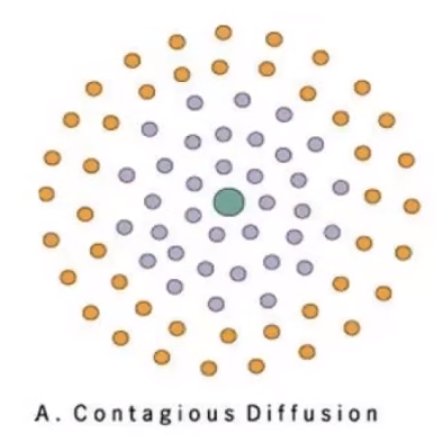
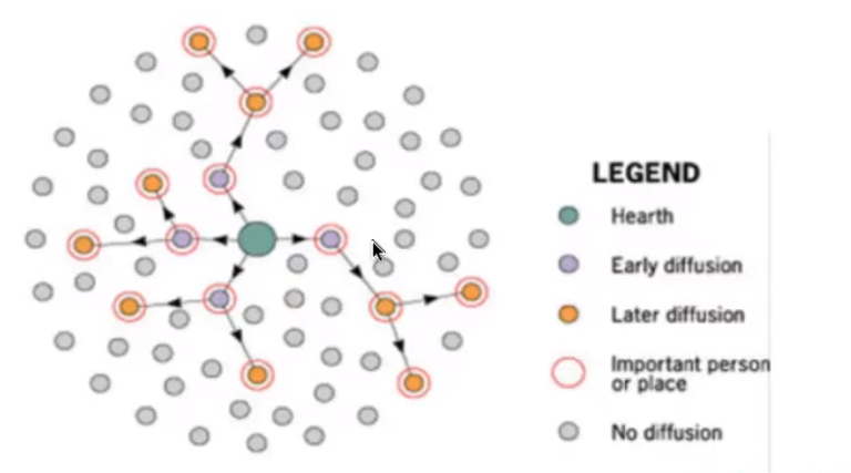
- Relocation and expansion — including contagious, hierarchical, and stimulus expansion — are types of diffusion
- Relocation — hearth moves
- act of people physically moving
- takes time, typically slow
- not everyone is going to absorb it
- term: person who uses a term moves to a new location and continues to use the term in the new location, OR a form of media, in which a term is used, is relocated to a new place and the term is used in the new location.
- Example: Spread of Christianity, when people moved and brought it with them
- expansion — hearth stays same place
- contagious
- diseases
- rapid spread
- term: an individual uses, or individuals use, the new word and then acquaintances (or those in close proximity to them) begin to use the word as well
- Example: Hinduism spreading throughout the Indian subcontinent
- hierarchical
- intent is to spread selectively
- term: celebrities start to use the new word and then it spreads to others down the social hierarchy OR people in large cities start to use the word and then the word eventually gets to smaller places or media markets, OR Reverse Hierarchical: minority use of the term spreads up the social ladder to majority group(s).
- spread by choice, often wealth
- stimulus
- innovative idea diffuses from its hearth outward, but the original idea is changed by the new adopters
- Example: Different Menu items from McDonalds around the world.
- contagious
3.5 Historical Causes of Diffusion #
SPS-3 Cultural ideas, practices, and innovations change or disappear over time.
- Learning Objective: Explain how historical processes impact current cultural patterns.
- Essential Knowledge:
- Interactions between and among cultural traits and larger global forces can lead to new forms of cultural expression; for example, creolization and lingua franca.
- lingua franca
- a language that is informally agreed upon as the language of business and trade
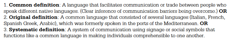
- Reasons for US being lingua franca / dominant
- Historical
- Globalization
- Historical
- a language that is informally agreed upon as the language of business and trade
- creolization
- mix of languages that form its own language
- native to some group of people
- vocab from different language
- pidgin
- no ones native language
- usually result of trading between groups of people who don’t share the same language
- lingua franca
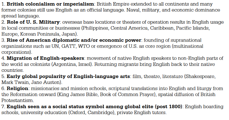
- Colonialism, imperialism, and trade helped to shape patterns and practices of culture.
- Colonialism + imperialism
- The widespread diffusion of English is thanks, in large part, to the colonial practices of the British
- trade
- Colonialism + imperialism
- Interactions between and among cultural traits and larger global forces can lead to new forms of cultural expression; for example, creolization and lingua franca.
3.6 Contemporary Causes of Diffusion #
SPS-3 Cultural ideas, practices, and innovations change or disappear over time.
- Learning Objective: Explain how historical processes impact current cultural patterns.
- Essential Knowledge:
- Cultural ideas and practices are socially constructed and change through both small-scale and large-scale processes such as urbanization and globalization. These processes come to bear on culture through media, technological change, politics, economics, and social relationships.
- sense of place is the special perception we have of a certain place based on our feelings, emotion, and associations with that place.
- also called distinctive culture
- also called distinctive culture
- Placelessness is he loss of a place’s unique favor and identity because of standardizing influence of popular culture and globalization
- sense of place is the special perception we have of a certain place based on our feelings, emotion, and associations with that place.
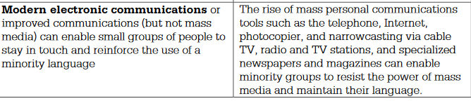
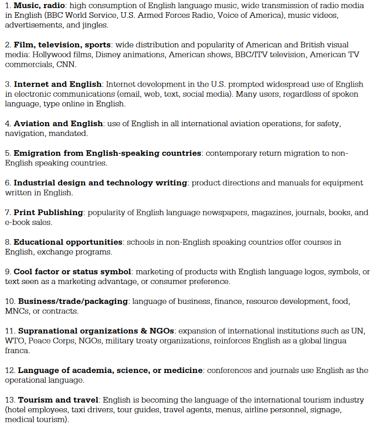
- Communication technologies, such as the internet and the time-space convergence, are reshaping and accelerating interactions among people; changing cultural practices, as in the increasing use of English and the loss of indigenous languages; and creating cultural convergence and divergence.
- the internet has united us more
- pros
- easier to share + spread culture
- english is language of the internet, universal
- cons
- culture can be easily judged without full context
- english is prereq and reducing usage of other languages
- pros
- the internet has united us more
- Cultural ideas and practices are socially constructed and change through both small-scale and large-scale processes such as urbanization and globalization. These processes come to bear on culture through media, technological change, politics, economics, and social relationships.
3.7 Diffusion of Religion and Language #
IMP**-3 The** interaction of people contributes to the spread of cultural practices.
- Learning Objective: Explain what factors lead to the diffusion of universalizing and ethnic religions.
- Essential Knowledge:
- Language
- Language families, languages, dialects, world religions, ethnic cultures, and gender roles diffuse from cultural hearths.
- Diffusion of language families, including Indo-European, and religious patterns and distributions can be visually represented on maps, in charts and toponyms, and in other representations.
- Religion
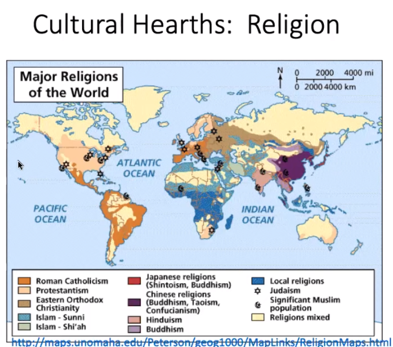
- Hinduism
- Hearth: Pakistan in ~2300 BCE
- Because Hinduism is an ethnic religion it primarily diffused via relocation diffusion to India and Nepal
- Judaism
- Hearth: Isreal/Palestine in ~1800 BCE
- Due to persecution from many countries, Judaism has diffused across many countries but is most prominent in Isreal and the United States now.
- Christianity
- Hearth: Jerusalem on 1 AD
- Christianity largely spread due to conquest throughout much of the Roman Empire, and again later on through colonialism. Now it’s the most practiced religion and is most influential in Europe, the Americas, South Africa, and Australia
- Islam
- Hearth: Arabian Peninsula/Saudi Arabia in ~600 CE
- Spread via conquest and trade, concentrated primarily in the Middle East, North Africa, Southwest Asia, and some portions of Southeast Asia
- Buddhism
- Hearth: Nepal in ~500 BCE
- Missionaries and trade helped diffuse Buddhism, and it’s not found in Southeast and East Asia, India, Sri Lanka, and Tibet
- Religion can identify, unit, or divide a group of people
- RELIGION IS ARGUABLY THE MOST VOLITALE OF ALL HUMAN RELATIONS AND THE SOURCE OF MOST VIOLENCE THROUGHOUT HISTORY.
- EUnion forbid any religious symbols such as crucifixes, crosses, etc. on public school walls and calls them a violation of religious and educational freedom
- Religion is nearly always suppressed in communist countries. Leaders believe that religion has a tendency to upset stability and therefore ban it altogether, though often they just concrete the people’s religious adherence instead of destroying it.
- Religions have distinct places of origin from which they diffused to other locations through different processes. Practices and belief systems impacted how widespread the religion diffused.
- Romans came and pushed out Jews, forcing them to diffuse
- Many religions spread via trade routes
- Christian countries tended to have many trade routes, so it spread to a range of areas
- Islamic countries didn’t trade very far outside Africa and Asia (a bit to Europe)
- Buddhism barely diffused from Asia
- Universalizing religions, including Christianity, Islam, Buddhism, and Sikhism, are spread through expansion and relocation diffusion.
- Anyone can become a member of a universalizing religion
- universalizing religion stories often attempt to explain the mystical and there calendar’s main purpose in calendars is to commemorate events in the founder’s life, thus the seasons or weather are not central to the structure
- Christianity, Buddhism, and Islam are the three main
- Buddhism and Islam are the universalizing religions that place the most emphasis on identifying shrines/holy places.
- In universalizing religions, the holy places are generally locations at which memorable events happened in the founder’s life, such as Mecca is in Islam because it is Muhammad’s birthplace.
- Holy places in ethnic religions are often physical features that are closely tied to the religion (For example, in Hindu one of the most important rituals is the bathing of oneself in the Ganges River.)
- Buddhism and Islam are the universalizing religions that place the most emphasis on identifying shrines/holy places.
- Members actively proselytize, or seek new converts by sending missionaries through the world to spread their beliefs
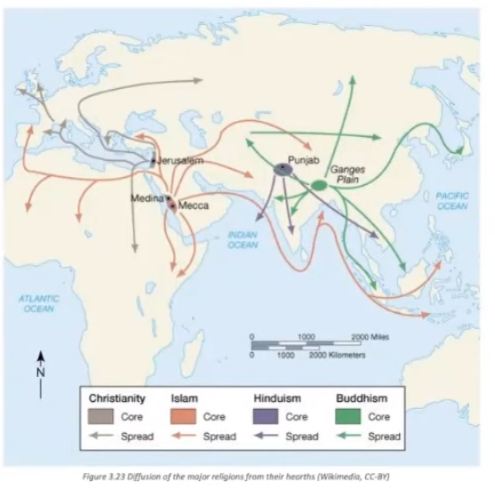 Excluding Hinduism, this shows diffusion of universalizing religions
- Ethnic religions, including Hinduism and Judaism, are generally found near the hearth or spread through relocation diffusion.
- Only really spread from generation to generation
- Ethnic religious creation stories tend to deal with the physical environment and natural events and typically organize their calendars around the seasons, other natural events, or the physical geography
- Ethnic religions rarely diffuse, and when they do, it is to a small extent
- Judaism is an exception in that it has diffused widely throughout the years, mainly because its people have had to flee persecution from many areas in the world.
- Traditional religions
- subgroup of ethnic
- practiced by small groups, typically within a village or tribe
- Hinduism
- Language
3.8 Effects of Diffusion #
SPS-3 The interaction of people contributes to the spread of cultural practices.
- Learning Objective: Explain how the process of diffusion results in changes to the cultural landscape
- Essential Knowledge:
- Acculturation, assimilation, syncretism, and multiculturalism are effects of the diffusion of culture.
- Acculturation
- process of adopting some of the values, customs, and behaviors of the host culture
- immigrants may adopt the language and a few other customs of the host group but will retain many distinctive customs
- assimilation
- Assimilation is the process whereby individuals or groups of differing ethnic heritage are totally absorbed into the dominant culture of a society.
- The process of assimilating involves taking on the traits of the dominant culture to such a degree that the assimilating group becomes socially indistinguishable from other members of the society.
- as we become more assimilated, languages become lost
- syncretism
- blending of cultures and ideas from different places
- multiculturalism
- grouping of various cultures in a certain area
- can lead to loss of cultural uniqueness, languages, and general “sameness” — link
🏛️Unit 4 - Political Patterns and Processes #
Developing Understanding
This unit addresses the political organization of the world. Building on knowledge of populations and cultural patterns learned in previous units, students examine the contemporary political map and the impact of territoriality on political power and on issues of identity for peoples. Students also look at the different types of political boundaries, how they function, and their scale, as they consider both internal and international boundaries. The interplay of political and cultural influences may cause tensions over boundaries to arise, such as sovereign states making claims on what other states consider to be international waters. Students also examine forms of government and how forces such as devolution may alter the functioning of political units and cause changes to established political boundaries. Separatist and independence movements that challenge the sovereignty of political states may arise from economic and nationalistic forces, as seen in Scotland, Northern Ireland, and Spain. The influence of supranational organizations such as the United Nations or European Union and their role in global affairs presents another challenge to nationalist sovereignty. Student understanding of cultural patterns and processes helps inform their understanding of the consequences of centrifugal and centripetal forces.
BIG IDEA 1Patterns and Spatial Organization (PSO)
- How do historical and current events influence political structures around the world? BIG IDEA 2 Impacts and Interactions (IMP)
- How are balances of power reflected in political boundaries and government power structures? BIG IDEA 3Spatial Processes and Societal Change (SPS)
- How can political, economic, cultural, or technological changes challenge state sovereignty?
4.1 Introduction to Political Geography #
PSO-4 The political organization of space results from historical and current processes, events, and ideas.
- Learning Objective: For world political maps: a. Define the different types of political entities. b. Identify a contemporary example of political entities.
- Essential Knowledge:
- Independent states are the primary building blocks of the world political map.
- Types of political entities include nations, nation-states, stateless nations, multinational states, multistate nations, and autonomous and semiautonomous regions, such as American Indian reservations.
- state:
- a country and not a political subdivision within the united states, such as Nevada or Maine
- has sovereignty, boundaries, and a permanent population
- nations:
- unified group of people with a common culture
- Navajo, Roma
- nation-states:
- States in which over 90 percent of the population are the same specific culture or group of people
- A politically organized area in which nation and state occupy the same space.
- can act as a centripetal factor to those of the same ethnicity as majority
- Japan, Iceland, Armenia, Bangladesh, Lesotho
- stateless nations
- A nationality that is not represented by a state.
- multinational states
- states made up of a two or more ethnic groups
- United states, Canada, China, Russia, India, Brazil
- multistate nations
- country with two or more nationalities within its borders (a nation that exists in multiple states)
- Kurds, French, Basque
- Buffer state
- States that are allowed to exist by neighboring states (to help relieve tension between the neighboring states).
- Mongolia between China and Russia
- autonomous
- a group of people or territory are self-governing, thus not under the control of a higher level of government
- semiautonomous regions
- a group of people that have some level of automity, but are still controlled by another entity
- state:
4.2 Political Processes #
PSO-4 Explain the processes that have shaped contemporary political geography.
- Learning Objective: Explain the processes that have shaped contemporary political geography.
- Essential Knowledge:
- The concepts of sovereignty, nation-states, and self-determination shape the contemporary world
- sovereignty
- internationally recognized exercise of a country’s power over its people and territory
- nation-states
- self-determination
- the concept that ethnicities have the right to govern themselves
- can lead to irredentism
- sovereignty
- Colonialism, imperialism, independence movements, and devolution along national lines have influenced contemporary political boundaries.
- Colonialism
- when a group of people impose a set of formal controls by the mother country over its colonies or outside territories
- Colonizers colonize because of
- Gold — seek monitary gains at (most of the time) any expense
- God — want to spread there own religion
- Glory — clout
- Effects still present today
- Social unrest
- typically speak langauge of colonizers
- French in Northern Africa, English (British) in Southern Africa
- boundaries expand that aren’t physically connected to mother country
- imperialism
- the use of military, cultural domination, and or economic sanctions to gain control of a country and its resources
- boundaries expand from mother country
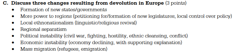
- independence movements
- can result in section breaking off
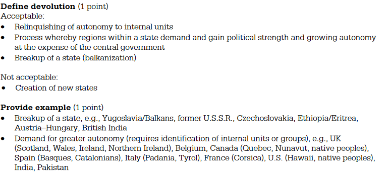
- devolution
- Quizlet
- the transition of power from the central government to regional governments in a state
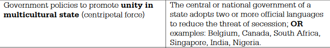
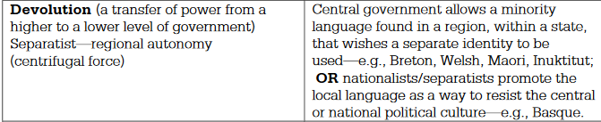
- is done by
- Altering of a constitution
- Experiments on new governmental body
- Internal Division (Ethnocultural, Economic, or Spatial)
- results in
- Creation of an independent state
- Calls for Autonomy
- can result in section breaking off
- Colonialism
- The concepts of sovereignty, nation-states, and self-determination shape the contemporary world
4.3 Political Power and Territoriality #
PSO-4 Explain the processes that have shaped contemporary political geography.
- Learning Objective: Describe the concepts of political power and territoriality as used by geographers
- Essential Knowledge:
- Political power is expressed geographically as control over people, land, and resources, as illustrated by neocolonialism, shatter belts, and choke points.
- neocolonialism
- Refers to the economic control that MDCs are sometimes believed to have over LDCs.
- Through organizations such as the IMF, the MDCs are able to dictate precisely what LDCs economic policies are, or are able to use their economic subsidies to put LDCs industries out of business.
- shatter belts
- an area of instability between regions with opposing political and cultural values
- choke points
- A geographical land feature such as a valley or water way narrowing causing a decrease in forces making their way through.
- neocolonialism
- Territoriality is the connection of people, their culture, and their economic systems to the land.
- boundaries are set to connect people with same/similar culture and that want to have an economic relation with one anther
- Stages of Economic Growth and Core Periphery Model (Core-Periphery)
 Core Periphery
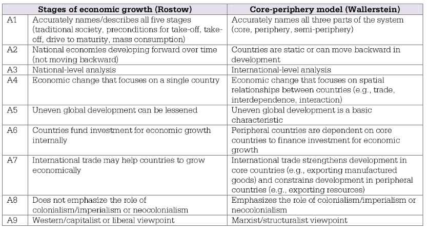
- Stages of each
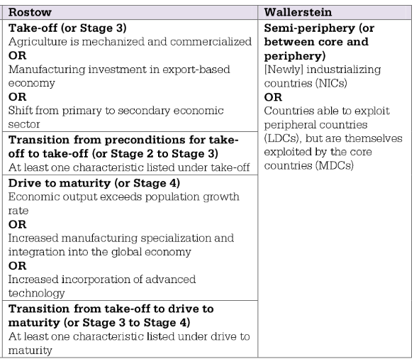
 Reasons for economic location
 - Core-periphery leads to uneven spatial distribution of economic, political, or cultural power
- Stages of each
- Political power is expressed geographically as control over people, land, and resources, as illustrated by neocolonialism, shatter belts, and choke points.
4.4 Defining Political Boundaries #
IMP-4.Political boundaries and divisions of governance, between states and within them, reflect balances of power that have been negotiated or imposed.
- Learning Objective: Define types of political boundaries used by geographers.
- Essential Knowledge:
- Types of political boundaries (barriers)include relic, superimposed, subsequent, antecedent, geometric, and consequent boundaries.
- relic
- boundary that used to exist, but is no longer active / present
- You can often still see effects of relic boundary even if they aren’t there
- e.g. great wall of China, East and West Germany
- superimposed
- boundary imposed by an outside force
- may not reflect cultural landscape
- e.g. treaties, Africa during Colonial era
- subsequent
- corresponds to group that is there, often regardless of cultural divide
- boundary set after the settlements of different groups meet
- often correspond to ecumene
 wall impacts
- consequent boundaries
- A boundary line that coincides with some cultural divide, such as religion or language.
- E.g. India
- antecedent
- pre-existing; most commonly physical features such as rivers, bays, mountains, desserts
- can potentially be removed with technology
- road build across dessert
- whole through mountain
- geometric
- straight lines
- US-Canada boarder
- because they aren’t visible, can lead to conflict
- Shapes
- compact
- round
- easy defense and communication
- prorupted or protruded
- round with a large extension
- increases access to resources or water/ports
- elongated
- long, narrow
- difficult communication between areas
- fragmented
- two or more areas separated by another country or body of water
- difficult communication
- perforated
- totally surrounds another country
- can abuse country w trade taxes/tariffs
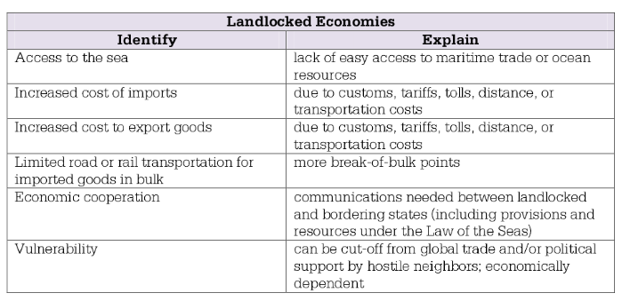
- landlocked
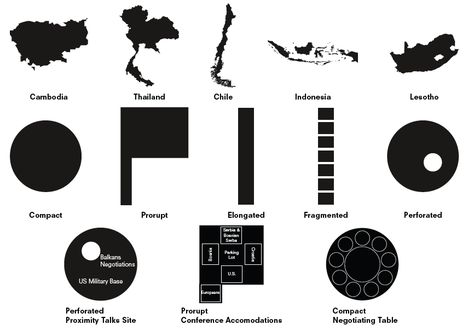
- compact
- relic
- Types of political boundaries (barriers)include relic, superimposed, subsequent, antecedent, geometric, and consequent boundaries.
4.5 The Function of Political Boundaries #
IMP-4. Political boundaries and divisions of governance, between states and within them, reflect balances of power that have been negotiated or imposed.
- Learning Objective: Explain the nature and function of international and internal boundaries.
- Essential Knowledge:
- Boundaries are defined, delimited, demarcated, and administered to establish limits of sovereignty, but they are often contested.
- defined
- Treaty or legal document
- delimited
- Drawn on map in agreement
- demarcated
- VISUALLY MARKED
- walls, posts, fence
- administered
- the enforcement & maintaining of a boundary by government
- who can cross?
- what goods can cross?
- demarcated?
- defined
- Political boundaries often coincide with cultural, national, or economic divisions. However, some boundaries are created by demilitarized zones or policy, such as the Berlin Conference.
- most of the time are made to not piss people / countries off if made by a supranational org
- Land and maritime boundaries and international agreements can influence national or regional identity and encourage or discourage international or internal interactions and disputes over resources.
- The United Nations Convention on the Law of the Sea defines the rights and responsibilities of nations in the use of international waters, established territorial seas, and exclusive economic zones.
- UN came up with these zones

- EEZ is important because you can tax ships that travel and make money
- Includes islands too which has put pressure / created conflict at some islands
- South China Sea
- Includes islands too which has put pressure / created conflict at some islands
- UN came in because otherwise it was hard to figure out who owned what area and lead to conflicts
- UN came up with these zones
- Boundaries are defined, delimited, demarcated, and administered to establish limits of sovereignty, but they are often contested.
4.6 Internal Boundaries #
IMP-4.Political boundaries and divisions of governance, between states and within them, reflect balances of power that have been negotiated or imposed.
- Learning Objective: Explain the nature and function of international and internal boundaries.
- Essential Knowledge:
- Voting districts, redistricting, and gerrymandering affect election results at various scales.
- Voting districts
- subsections in states specifically for voting
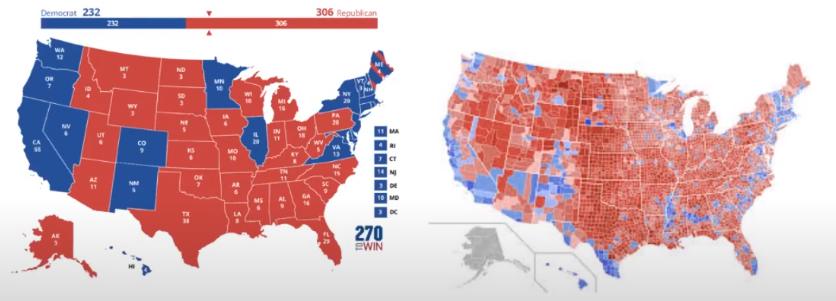
- subsections in states specifically for voting
- redistricting
- occurs once in every 10 years in US after census
- goal is to be drawn fairer and group like people
- often results in gerrymandering
- gerrymandering
- redistricting in such a way that it favors a political party
- Voting districts
- Voting districts, redistricting, and gerrymandering affect election results at various scales.
4.7 Forms of Governance #
IMP-4.Political boundaries and divisions of governance, between states and within them, reflect balances of power that have been negotiated or imposed.
- Learning Objective: Define federal and unitary states.
- Essential Knowledge:
- Forms of governance include unitary states and federal states
- unitary states
- most power lies in centralized govt
- areas far away from central power aren’t represented equally
- can pull a country together
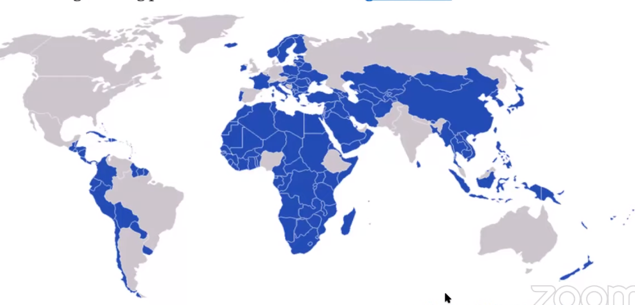
- federal states
- most power lies in local govt
- country is split into states / provinces, typically to group like-people
- can better represent areas
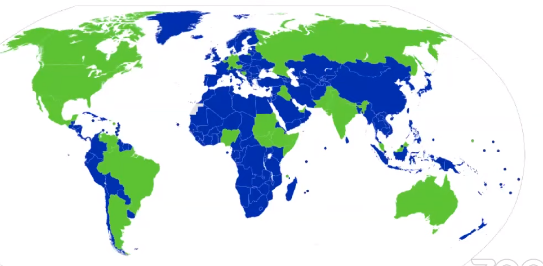 Green = Federal
- most power lies in local govt
- unitary states
- Forms of governance include unitary states and federal states
- Learning Objective: Explain how federal and unitary states affect spatial organization.
- Essential Knowledge:
- Unitary states tend to have a more top-down, centralized form of governance, while federal states have more locally based, dispersed power centers.
- unitary states
- focus on central government or big city
- federal states
- multiple nodal points
- stateless
- compact around a center nodal point
- small boarders
- unitary states
- Unitary states tend to have a more top-down, centralized form of governance, while federal states have more locally based, dispersed power centers.
4.8 Defining Devolutionary Factors #
SPS-4.Political, economic, cultural, or technological changes can challenge state sovereignty.
- Learning Objective: Define factors that lead to the devolution of states
- Essential Knowledge:
- Factors that can lead to the devolution of states include the division of groups by physical geography, ethnic separatism, ethnic cleansing, terrorism, economic and social problems, and irredentism.
- physical geography
- if state is physically separated by land, water, etc.
- ethnic separatism
- rise of ethnic groups in a state that want there own statehood
- ethnic cleansing
- not genocide
- genocide = killing people
- ethnic cleansing is moving certain people out
- not genocide
- political justification
- Heartland-rimland theory
- justified eu colonization during 19th century by claiming EU was the heartland and the surrounding territories comprised of the rimland
- the heartland was well positioned to dominate the world because of the immense size of its mass.
- since Russia formed the major part of the heartland, Mackinder (creator of theory) influenced politicians of the day to try to limit Russia’s expansion by colonizing territories near Russia
- tl;dr — Politicians used some crappy justification that aligned with the biases to further there agenda
- domino thoery
- once a country became communist, the neighboring countries around it were likely to also become communist
- Heartland-rimland theory
- terrorism
- goal is to intimidate or coerce a govt to do the terrorists political or social objective
- serves to pull country apart
- economic
- richer areas can want to split off so that they don’t have to pay a majority in taxes to people they don’t know/relate to
- social problems
- due to differences between cultural groups
- irredentism
- the goal of a group of people to want to unit with another group of people who share cultural elements with, but are divided by national boundaries
- can result in civil wars
4.9 Challenges to Sovereignty #
SPS-4.Political, economic, cultural, or technological changes can challenge state sovereignty.
- Learning Objective:
Explain how political, economic, cultural, and technological changes challenge state sovereignty.
- political
- superimposed boarders can lead to people upset
- economic
- area wanting less taxes because they’re paying an unequal amount
- terrorist groups attacking transportation / pipes
- cultural
- e.g. one group wanting an official language and another group wanting a different official language
- political
- Essential Knowledge:
- Devolution occurs when states fragment into autonomous regions; subnational political territorial units, such as those within Spain, Belgium, Canada, and Nigeria; or when states disintegrate, as happened in Sudan and the former Soviet Union.
- autonomous regions; subnational political territorial units
- Link
- E.g. Spain, Belgium, Canada, and Nigeria
- disintegrate
- E.g. Sudan and the former Soviet Union
- autonomous regions; subnational political territorial units
- Advances in communication technology have facilitated devolution, supranationalism, and democratization.
- devolution — link
- supranationalism
- easier to connect with similar people and want to join them
- Political, economic, and/or cultural cooperation among national states to promote shared objectives
- Tendency for states to give up political power to a higher authority in pursuit of common objectives (political, economic, military, environmental)
- Venture involving multiple national states (two or more, many, several) with a common goal
- democratization
- easier to see how much better it is outside your country with internet
- Global efforts to address transnational and environmental challenges and to create economies of scale, trade agreements, and military alliances help to further supranationalism.
- economies of scale
- trade agreements
- military alliances
- Supranational organizations—including the United Nations (UN), North Atlantic Treaty Organization (NATO), European Union (EU), Association of Southeast Asian Nations (ASEAN), Arctic Council, and African Union— can challenge state sovereignty by limiting the economic or political actions of member states.
- international group which the power and influence of member states transcend national boundaries or interest to share in decision making and vote on issues concerning the collective body
- member states give up some rights for common good of supranational organziation
- cooperation should resolve conflict
- sometimes used for collective defense
- can make economic stuff easier by opening boarders to member states
- set standards
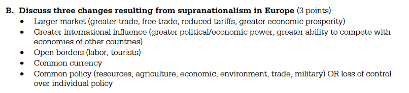
- Devolution occurs when states fragment into autonomous regions; subnational political territorial units, such as those within Spain, Belgium, Canada, and Nigeria; or when states disintegrate, as happened in Sudan and the former Soviet Union.
4.1 Consequences of Centrifugal and Centripetal Forces #
SPS-4.Political, economic, cultural, or technological changes can challenge state sovereignty.
- Learning Objective: Explain how the concepts of centrifugal and centripetal forces apply at the state scale.
- Essential Knowledge:
- Centrifugal forces may lead to failed states, uneven development, stateless nations, and ethnic nationalist movements.
- failed states
- political body that has disintegrated to a point where basic conditions and responsibilities of a sovereign govt no longer function
- most LDCs
- uneven development
- tend to be poor with corrupt govt
- stateless nations
- can serve as a centrifugal factor to state they’re in
- united inside there own area
- typically grouped by ethnic groups
- ethnic nationalist movements
- lead to separation movements
- riots against govt if not adequately represented
- failed states
- Centripetal forces can lead to ethnonationalism, more equitable infrastructure development, and increased cultural cohesion.
- ethnonationalism
- nationalism of people with common background / language unites people
- more equitable infrastructure development
- increased cultural cohesion
- ethnonationalism
- Centrifugal forces may lead to failed states, uneven development, stateless nations, and ethnic nationalist movements.
🚜Unit 5 — Agriculture and Rural Land-Use Patterns and Processes #
Developing Understanding
This unit examines the origins of agriculture and its subsequent diffusion. Students learn about the ways agricultural practices have changed over time as a result of technological innovations, such as equipment mechanization and improvements in transportation that create global markets. In addition, they examine the consequences of agricultural practices such as the use of high-yield seeds and chemicals, revisiting the human–environmental relationships studied in Unit 1. Course emphasis on spatial patterns is evident in this unit as students consider the differences in what foods or resources are produced and where they are produced. These agricultural production regions are impacted by economic and technological forces that increase the size of agricultural operations and the carrying capacity of the land. This has in turn created a global system of agriculture and the interdependence of regions of agricultural consumption and production. Student understanding of this global system of agriculture based on government cooperation lays the foundation for a deeper understanding of economic development in the final unit of the course.
BIG IDEA 1Patterns and Spatial Organization (PSO)
- How do a people’s culture and the resources available to them influence how they grow food? BIG IDEA 2 Impacts and Interactions (IMP)
- How does what people produce and consume vary in different locations? BIG IDEA 3Spatial Processes and Societal Change (SPS)
- What kind of cultural changes and technological advances have impacted the way people grow and consume food?
5.1 Introduction to Agriculture #
PSO 5 Availability of resources and cultural practices influence agricultural practices and land-use patterns.
- Learning Objective: Explain the connection between physical geography and agricultural practices.
- Essential Knowledge:
- Agricultural practices are influenced by the physical environment and climatic conditions, such as the Mediterranean climate and tropical climates.
- During the First Agricultural Revolution:
- Sarted around 11,000 BC
- Unknown origins / how it happened (before recording of history)
- Humans radically changed their behavior:
- Went from hunting/gather life style to settling in to single areas and cultivating the land, planting crops, and raising animals
- Agriculture is impacted by:
- Land — cheap, near market + transportation, good quality soil
- Labor — cheap, skilled (enough), enough quantity
- Climate — have to meet requirements of crop, enough rain
- Mediterranean Agriculture:
- produces grapes and olives (cash crops), alongside citruses and figs — helps attract tourists, contributes to culture
- still produce cereals, especially wheat for pasta/bread
- requires warm year-round climate with lots of sunshine and boardering a sea
- horticulture: growing fruits, veggies, and flowers
- During the First Agricultural Revolution:
- Intensive farming practices include market gardening, plantation agriculture, and mixed crop/livestock systems.
- Land: Small — land isn’t cheap so only small portions of high quality land is used
- High yield (food produced) to feed consumers
- Location: Closest to market
- Relies on lots of labor and tech (pesticides, fertilizer, etc.)
- (Oftentimes) variety of products produced — polyculture
- Examples:
- market gardening
- close to market
- small scale production of cash crops: fruits, vegetables, and flowers (apples, asparagus, cherries, lettuce, mushrooms, tomatoes)
- sold directly to local consumers.
- truck farming: truck means “barter” or “exchange”, not a physical truck
- plantation agriculture (cash crop, cashcrop)
- highly efficient
- tend to be established in or near the tropics
- produce a cash crop
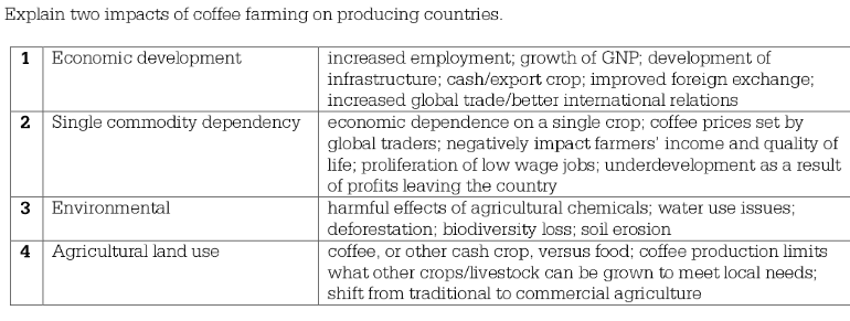
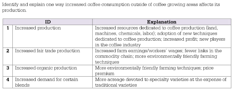
- mixed crop/livestock systems
- Both animal and crops are farmed in the same area.
- Most common form of agriculture in US
- Crops, like maize and soybeans, are grown primarily to feed animals
- Utilizes crop rotation: cycles various crops and fields left to fallow (naturally grow over) to allow nutrient replenishing
- China, India, and SE Asia rely on this type of agriculure to double-crop
- Fit 2 years of harvest in 1 year
- market gardening
- Extensive farming practices include shifting cultivation, nomadic herding, and ranching.
- Land: Large
- Location: Farther from market — land isn’t cheap so it’s not that great and far away from market
- Examples:
- Shifting cultivation
- (slash-and-burn) vegetation is cut down and then ignited to make the ground more productive
- low yield / ineffective
- occurs in tropics
- More notes
- Nomadic herding
- (animal husbandry) based on herding domesticated animals.
- can result in desertification
- low yield, but only needs to support tribe/family
- Ranching
- commercial grazing of livestock over an extensive area
- practiced is semi-arid or arid land, where vegetation is too sparse or the soil to too poor to support crops
- prominent in later 19th century in the American West;
- on the decline due to low profit margins — more intensive to go into mono farming
- Shifting cultivation
- Agricultural practices are influenced by the physical environment and climatic conditions, such as the Mediterranean climate and tropical climates.
5.2 Settlement Patterns and Survey Methods #
PSO 5 Availability of resources and cultural practices influence agricultural practices and land-use patterns.
- Learning Objective: Identify different rural settlement patterns and methods of surveying rural settlements.
- Essential Knowledge:
- Specific agricultural practices shape different rural land-use patterns.
- Rural defined as < 2500 residents, and between 1 and 999 person per square mile
- 3 factors that affect the pattern of rural setllement:
- The kind of resource/feature that attracts people to the area (forests, farmlands, fields)
- The transportation method avaliable at the time of settlement (rivers, roads)
- Role of government policy, especially the land survey system (metes-and-bonds, long lot, rectangle, etc.)
- Rural settlement patterns are classified as clustered, dispersed, or linear.
- clustered
- A clustered rural settlement typically includes homes, barns, tool sheds, and other farm structures, plus personal services, such as religious structures and schools.
- dispersed
- characterized by farmers living on individual farms isolated from neighbors rather than alongside other farmers in the area.
- linear
- Linear rural settlements feature buildings clustered along a road, river, or dike to facilitate communications.
- nucleated
- a number of families live in close proximity to each other, with fields surrounding the collection of houses and farm buildings (e.g., Asian longhouse)
- clustered
- Rural survey methods include metes and bounds, township and range, and long lot.
- Rectangular survey system
- Also called the Public Land Survey
- The system was used by the U.S. Land Office Survey to parcel land west of the Appalacian mountains.
- The system divides land into a series of rectangular parcels.
- metes and bounds
- A system of land surveying east of the Appalachian Mountains (EU)
- It is a system that relies on descriptions of land ownership and natural features such as streams or trees.
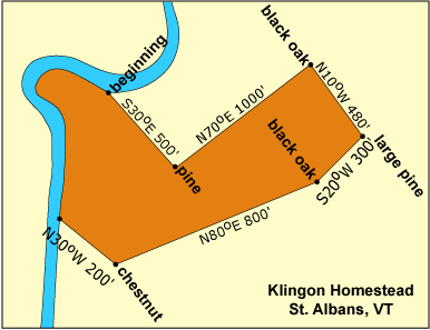
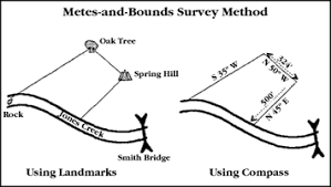
- township and range
- rectangular land division scheme designed by Thomas Jefferson
- grid system
- Intended to disperse settlers evenly across farmlands of the U.S. interior
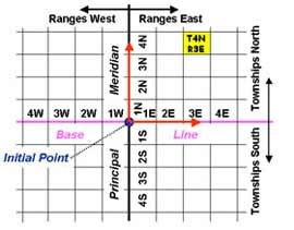
- long lot
- Distinct regional approach to land surveying found in the Canadian Maritimes, parts of Quebec, Louisiana, and Texas
- designed to give everyone an equal type of land / soil (one person shouldnt get all poor land / land on a road or river / etc.)
- Land is divided into narrow parcels stretching back from rivers, roads, or canals.
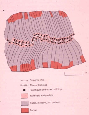
- Rectangular survey system
- Specific agricultural practices shape different rural land-use patterns.
5.3 Agricultural Origins and Diffusions #
SPS 5 Agriculture has changed over time because of cultural diffusion and advances in technology.
- Learning Objective: Identify major centers of domestication of plant sand animals.
- Essential Knowledge:
- Early hearths of domestication of plants and animals arose in the Fertile Crescent and several other regions of the world, including the Indus River Valley, Southeast Asia, and Central America.
- Fertile Crescent (Mesopotamia) — 10,000 years ago
- 1200 years ago it became good for sedentary agriculture
- In the Middle East that includes most of Iraq (Known as Mesopotamia in the past), Syria, Lebanon, Israel, and the Nile River basin in Egypt.
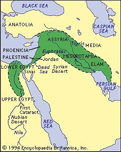
- Huang He (Yellow) Valley — 10,000 years ago
- Flooding of rivers resulted in people settling near them and using them to farm
- Barley, wheat, lentils, and olives
- Diffused west to EU + Central Asia
- Experienced the Primary Revolution later than in the Fertile Crescent/Mesopotamia
- Nile River Valley — 8,000 years ago
- Used crop rotation with lagoons and cereals to reduce salt build up
- Settlements around Nile
- Indus River Valley — 4,000 years ago
- Extended from modern-day northeast Afghanistan to Pakistan and northwest India.
- Important innovations of this civilization include standardized weights and measures, seal carving, and metallurgy with copper, bronze, lead, and tin.
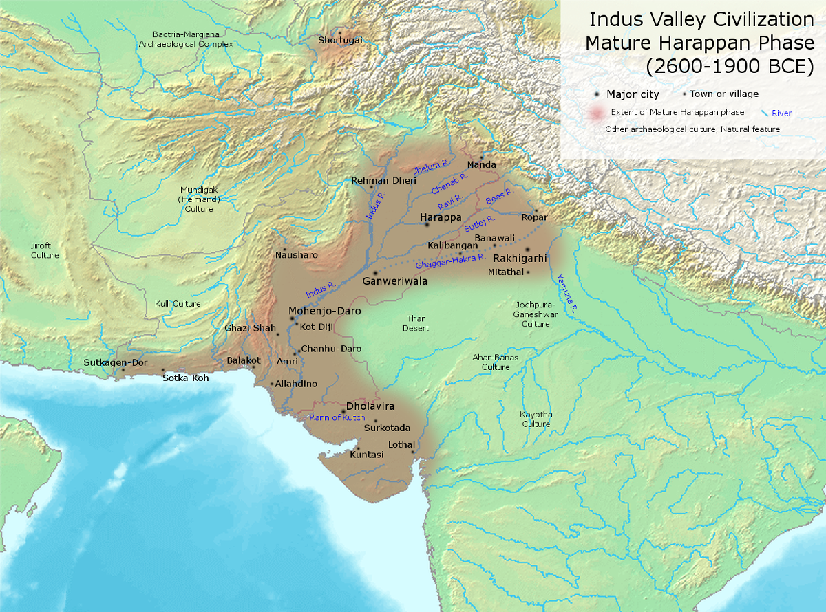
- Central America.
- Uncertain time period, but probably happened last
- Some scholars estimate 2000 BC, but may go up to the discovery of the Americas by the Europeans because some Native Tribes had not progressed to the First Agricultural Revolution by that time
- Beans, maize (corn), and cotton
- Diffused North and South
- Sub-Saharan Africa
- Sorghum, yams, milet, and rice
- 10,000 years ago
- Diffused south
- Fertile Crescent (Mesopotamia) — 10,000 years ago
- Early hearths of domestication of plants and animals arose in the Fertile Crescent and several other regions of the world, including the Indus River Valley, Southeast Asia, and Central America.
- Learning Objective: Explain how plants and animals diffused globally.
- Essential Knowledge:
- Patterns of diffusion, such as the Columbian Exchange and the agricultural revolutions, resulted in the global spread of various plants and animals.
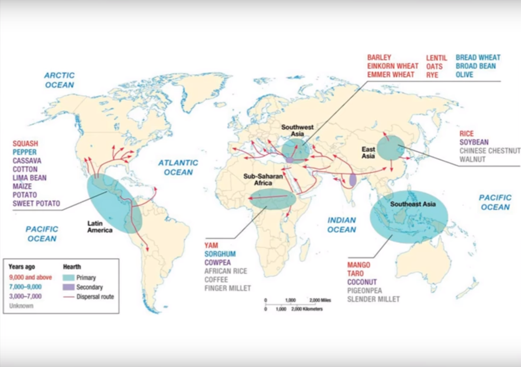
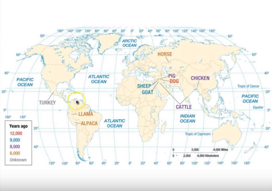
- Patterns of diffusion, such as the Columbian Exchange and the agricultural revolutions, resulted in the global spread of various plants and animals.
5.4 The Second Agricultural Revolution #
SPS 5 Agriculture has changed over time because of cultural diffusion and advances in technology.
- Learning Objective: Explain the advances and impacts of the second agricultural revolution.
- Essential Knowledge:
- New technology and increased food production in the second agricultural revolution led to better diets, longer life expectancies, and more people available for work in factories.
- Page 105 in Barron’s
- Occurred in 1700’s through 1940’s (alongside industrial revolution)
- Advances:
- Motors, specifically tractors, which further advanced stuff in the 1930’s
- People used crop rotation instead of letting land grow over
- Where:
- Happened in Europe and North America
- Started with horse-drawn hoes in England
- Happened in Europe and North America
- Outcomes:
- Surplus of crops in England diffused through EU
- People ate healthier because more food was available at lower prices
- Allowed more people to move to cities which led to industrial revolution
- women needed less kids for farms
- Farming changed from family to commercial enterprise (agribusiness) that emphasized single crops and profits
- Vertical integration (contracts between farmer and purchaser) caused farm outputs to increase by 1990s
- New technology and increased food production in the second agricultural revolution led to better diets, longer life expectancies, and more people available for work in factories.
5.5 The Green Revolution #
SPS 5 Agriculture has changed over time because of cultural diffusion and advances in technology.
- Learning Objective: Explain the consequences of the Green Revolution on food supply and the environment in the developing world.
- Essential Knowledge:
- The Green Revolution was characterized in agriculture by the use of high-yield seeds, increased use of chemicals, and mechanized farming
- Machines have replaced human labor
- New seeds, chemical pesticides, and fertilizers increased yield
- MDC often get newest tech first
- The Green Revolution had positive and negative consequences for both human populations and the environment.
- Started in mid-1970’s when scientists developed hybrid higher-yield seeds and new fertilizers to use alongside them.
- + New seeds and fertilizers diffused from core to periphery countries to help eradicate hunger
- + China, India, and SE Asia had rice harvests increase
- + Decrease land devoted to farms
- + Less expensive food
- + Reduce poverty
- + More consistent yield
- - Many poor farmers couldn’t afford new seeds
- - Africa couldn’t take advantage of seeds (there chief foods are millet, sorghum, yams, and cassavas
- - Increased irrigation, causing environmental damage
- - Focus on cash crops
- - Some soil has lost majority of nutrients due to over use
- - Biodiversity and native food crops have gone down, increased chance of blight
- The Green Revolution was characterized in agriculture by the use of high-yield seeds, increased use of chemicals, and mechanized farming
5.6 Agricultural Production Regions #
PSO Availability of resources and cultural practices influence agricultural practices and land-use patterns.
- Learning Objective: Explain how economic forces influence agricultural practices
- Essential Knowledge:
- Agricultural production regions are defined by the extent to which they reflect subsistence or commercial practices (monocropping or monoculture).
- Subsistence vs Commercial:
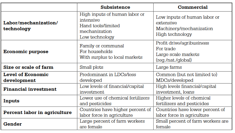
- Subsistence is :
- Food grown for the farmer or farmer’s family/kin
- Food grown for local consumption for village/community market
- Food NOT grown for commercial purposes/sold for revenue
- Subsistence is :
- Monocropping or Monoculture — cultivation of a single crop
- Occurs in mostly commercial farms in MDCs — US in 1950’s
- minimizes risks — climate, cost of inputs like labor or fertilizer, market demand, etc.
- maximize profits — choice of crop best suited for growing, potential pricing, etc.
- Supply and demands influences farmers to raise the crops that have high demands
- Governments disort market influence by subsidizing certain crops (rice in Japan, milk in US)
- Subsistence vs Commercial:
- Intensive and extensive farming practices are determined in part by land costs (bid-rent theory).
- bid-rent: geographical economic theory: refers to how the price and demand on real estate changes as the distance towards the Central Business District (CBD) increases.
- intensive agriculture: any kind of agriculture activity that involves effective and efficient use of labor on small plots of land to maximize crop yield
- extensive agriculture: an agricultural system characterized by low inputs of labor per unit land area
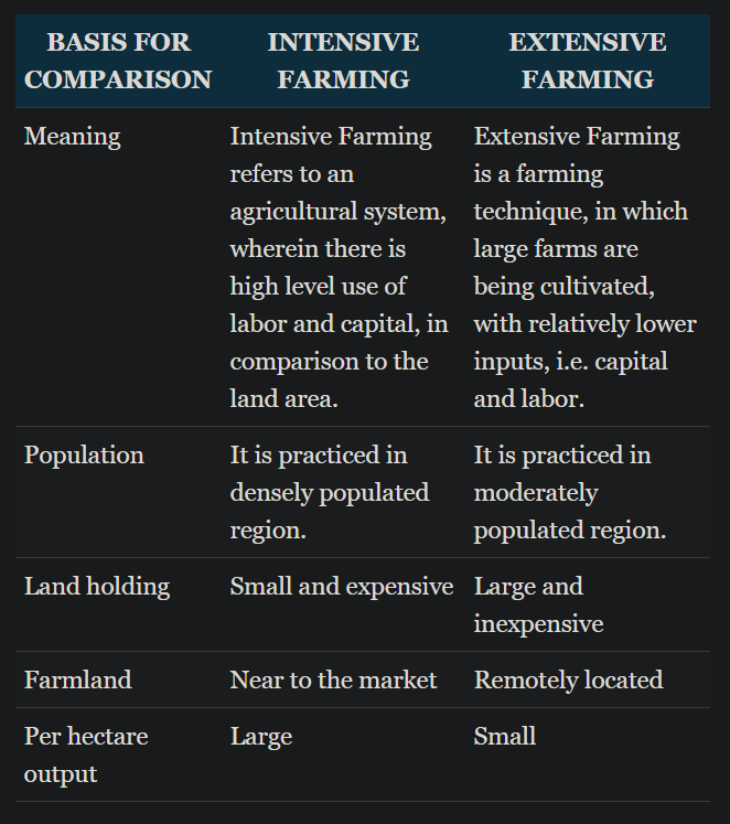
- Agricultural production regions are defined by the extent to which they reflect subsistence or commercial practices (monocropping or monoculture).
5.7 Spatial Organization of Agriculture #
PSO Availability of resources and cultural practices influence agricultural practices and land-use patterns.
- Learning Objective: Explain how economic forces influence agricultural practices.
- Essential Knowledge:
- Large-scale commercial agricultural operations are replacing small family farms.
- Occured during 20th century due to larger profits
- Further notes
- Complex commodity chains link production and consumption of agricultural products.
- Von Thunen
- Technology has increased economies of scale in the agricultural sector and the carrying capacity of the land.
- More food leads to people spending less time trying to figure out how to eat and shifting to figuring out how to grow / be smarter
- Technology has lead to intensive farming that has optimized how we use land
- Large-scale commercial agricultural operations are replacing small family farms.
5.8 Von Thünen (Thunen) Model #
PSO Availability of resources and cultural practices influence agricultural practices and land-use patterns.
- Learning Objective: Describe how the von Thünen model is used to explain patterns of agricultural production at various scales
- Essential Knowledge:
- Von Thünen’s model helps to explain rural land use by emphasizing the importance of transportation costs associated with distance from the market; however, regions of specialty farming do not always conform to von Thünen’s concentric rings.
- The closer the land is to the city, the more expensive it
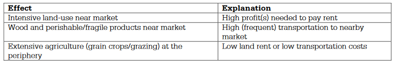
- Because perishable items, e.g. Milk, and difficult to transport items must be grown very closely to their market
- Milkshed is ring around market where dairy farming occurs
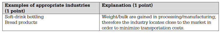
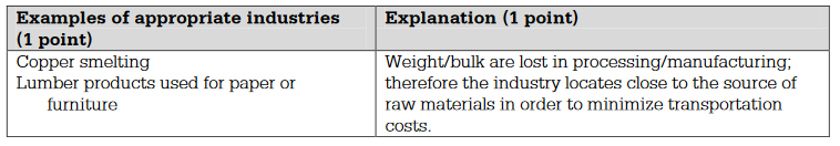
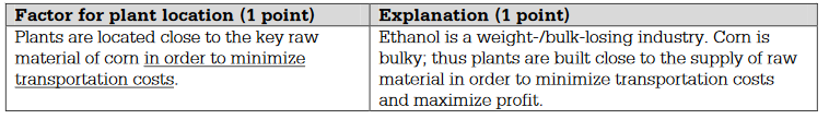 Weberian theory
- Milkshed is ring around market where dairy farming occurs
- Sort of not true with advances in transportation and that all land is able to support it’s designated task
- Because perishable items, e.g. Milk, and difficult to transport items must be grown very closely to their market
- Forest resources (needed for fuel) could be grown and harvested further out than fruits/veggies from the market
- Market example with automobiles
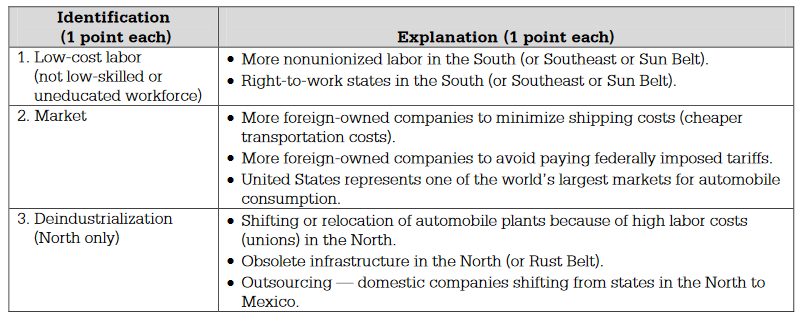
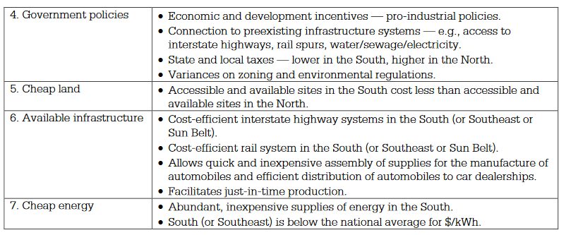
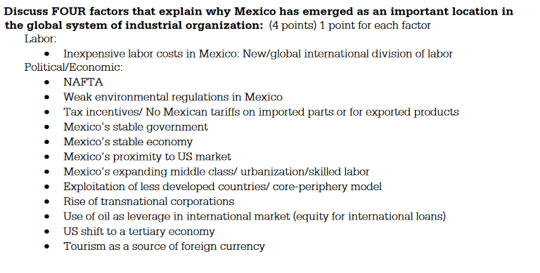
- Market example with automobiles
- Grain could be harvested even further out because it could be grown, harvested, and stored easily and cheaply until needed
- Limitations
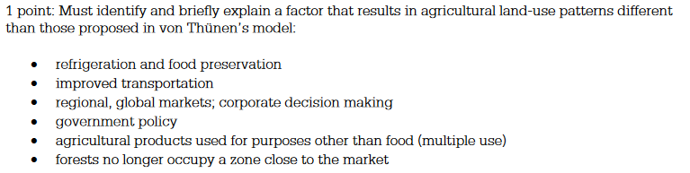
- Livestock then could be raised in the outer ring where cheap, larges pastures were pentiful
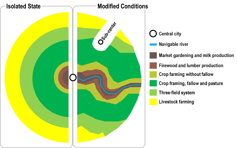
- The closer the land is to the city, the more expensive it
- Von Thünen’s model helps to explain rural land use by emphasizing the importance of transportation costs associated with distance from the market; however, regions of specialty farming do not always conform to von Thünen’s concentric rings.
5.9 The Global System of Agriculture #
PSO Availability of resources and cultural practices influence agricultural practices and land-use patterns.
- Learning Objective: Explain the interdependence among regions of agricultural production and consumption
- Essential Knowledge:
- Food and other agricultural products are part of a global supply chain.
- MDCs tend to have access to best tech and get far ahead compared to LDCs
- LDCs with land arable for certain foods may be funded by MDCs for a specific product that they (MDCs) can’t produce
- Some countries have become highly dependent on one or more export commodities.
- Country’s that have a monopoly on foods can exploit other countries that depend on them
- If there’s a pest+drought+other issue that stops production of producer country from making food, then all dependents are screwed too
- The main elements of global food distribution networks are affected by political relationships, infrastructure, and patterns of world trade.
- Tariffs can screw over trade agreements
- Country’s with more infrastructure are more likely to receive investment because its key to exporting goods
- Core-periphery model applies to agriculture
- Food and other agricultural products are part of a global supply chain.
5.1 Consequences of Agricultural Practices #
IMP Agricultural production and consumption patterns vary in different locations, presenting different environmental, social, economic, and cultural opportunities and challenges.
- Learning Objective: Explain how agricultural practices have environmental and societal consequences.
- Essential Knowledge:
- Environmental effects of agricultural land use include pollution, land cover change, desertification, soil salinization, and conservation efforts.
- pollution
- land cover change
- desertification
- overgrazing leads to land being perminent damage to land via erosion of unprotected topsoils
- soil salinization
- conservation efforts
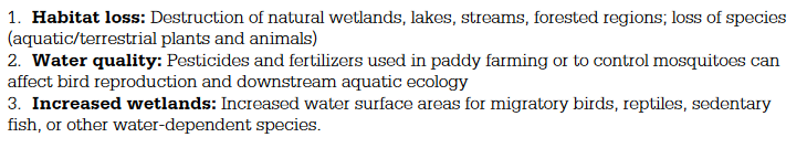 For rice farming
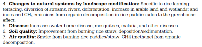 For rice farming
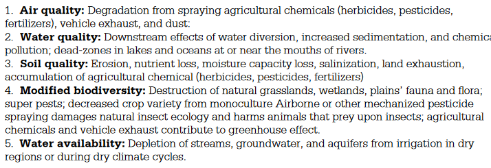 For mechanization / wheat farming
- Agricultural practices—including slash and burn, terraces, irrigation, deforestation, draining wetlands, shifting cultivation, and pastoral nomadism—alter the landscape.
- terraces
- creating an embankment (a terrance) at a right angle to sloping land in order to allow water to soak into the soil rather than move down the slope, taking the soil with it
- irrigation
- more efficient, developed to keep up with population demand
- deforestation
- plantation farming
- mainly specialize in 1-2 crops
- mostly in tropics, Latin America, Africa, some Asia
- Mostly produce prodcuts for sale is MDCs
- Intensive subsistence with wet rice dominant
- High agricultural density — lots of farmers, little land
- must produce enough food for family or small village
- wet rice:
- field prep: plow
- flooding: rain, river, or irrigation
- transplanting: rice seedling grow on dry land then moveod to flooded field to grow
- harvest: by hand
- double cropping: finishing 2 harvests in 1 year
- Intensive subsistence with wet rice NOT dominant
- climate prevents growing of rice in some regions where summer preciiptation is too low and/or winters are too harsh
- wheat, barley, millet, oats, corn, and some cash crops (cotton, flax, hemp) grown
- small land worked fulley
- commonly use crop rotation
- shifting cultivation
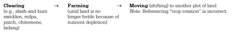
- based on growing crops in different fields on a rotating basis, e.g.
- Maya in the Yucatan grow maize by rotating fields (on a seven-year cycle)
- crops include rice, maize, manioc, millet, sorghum, yams, surgercane, veggies
- fields are cut and burned each year to enrich the soil with nutrients
- process called swidden or slash-and-burn
- seeds are planted in time for rainy season
- cultivated fields are used for two or three years until all nutrients are used
- critics it should be replaced by a more efficient means
- defenders say it is the most environmentally sound approach
- occupies 25% of world’s land, but practiced by just 5% of people
- used to be tradiationally done by village, now mostly private companies
- being replaced by logging, ranching, and cashcrops (monofarming)
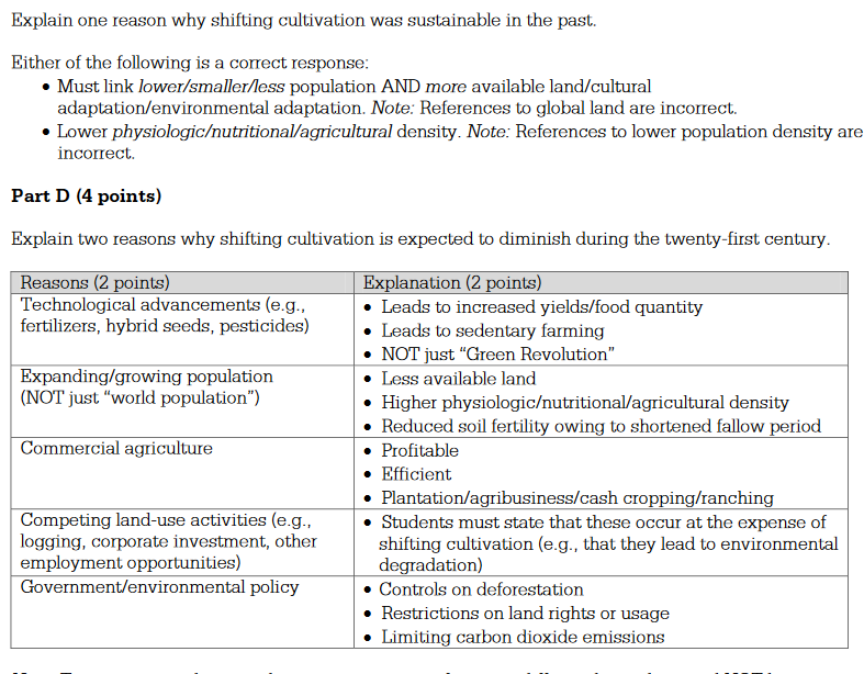
- based on growing crops in different fields on a rotating basis, e.g.
- pastoral nomadism
- animals are herded in a seasonal migratory pattern
- 200+ million pastoralists in the world
- often cattle, goats, sheet, camels, and reindeer
- often in arid, marginal alnds — N Africa, Central Asia, Middle east
- when herds are moved from land to land, it’s called transhumance
- declining in popularity because modern tech can make better use of pastures
- mining, irrigation, petroleum
- terraces
- Societal effects of agricultural practices include changing diets, role of women in agricultural production, and economic purpose.
- changing diets
- food security plays a large role in LDCs
- you can’t flourish if you’re physical and mental power is spent on getting food
- maps
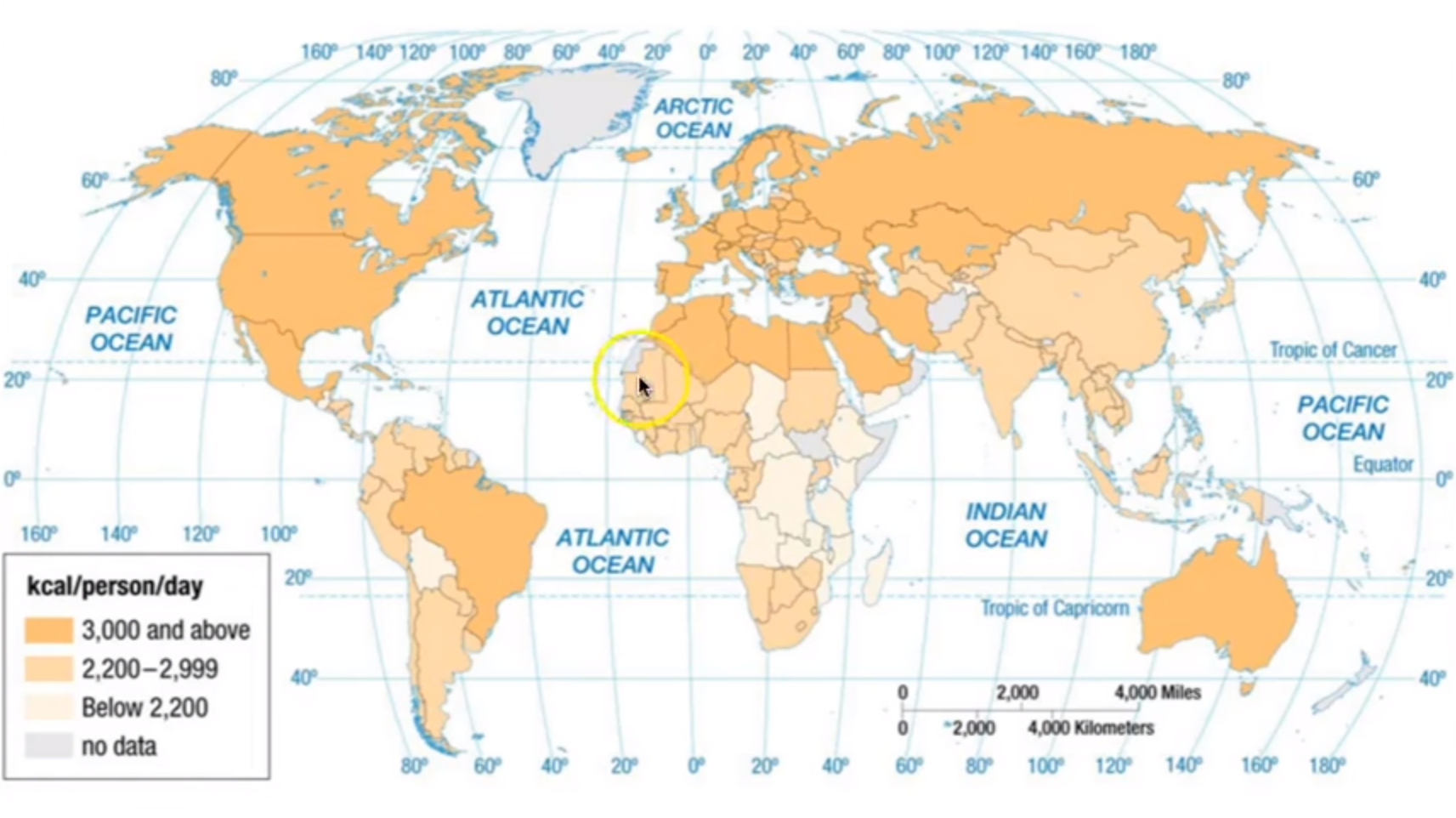
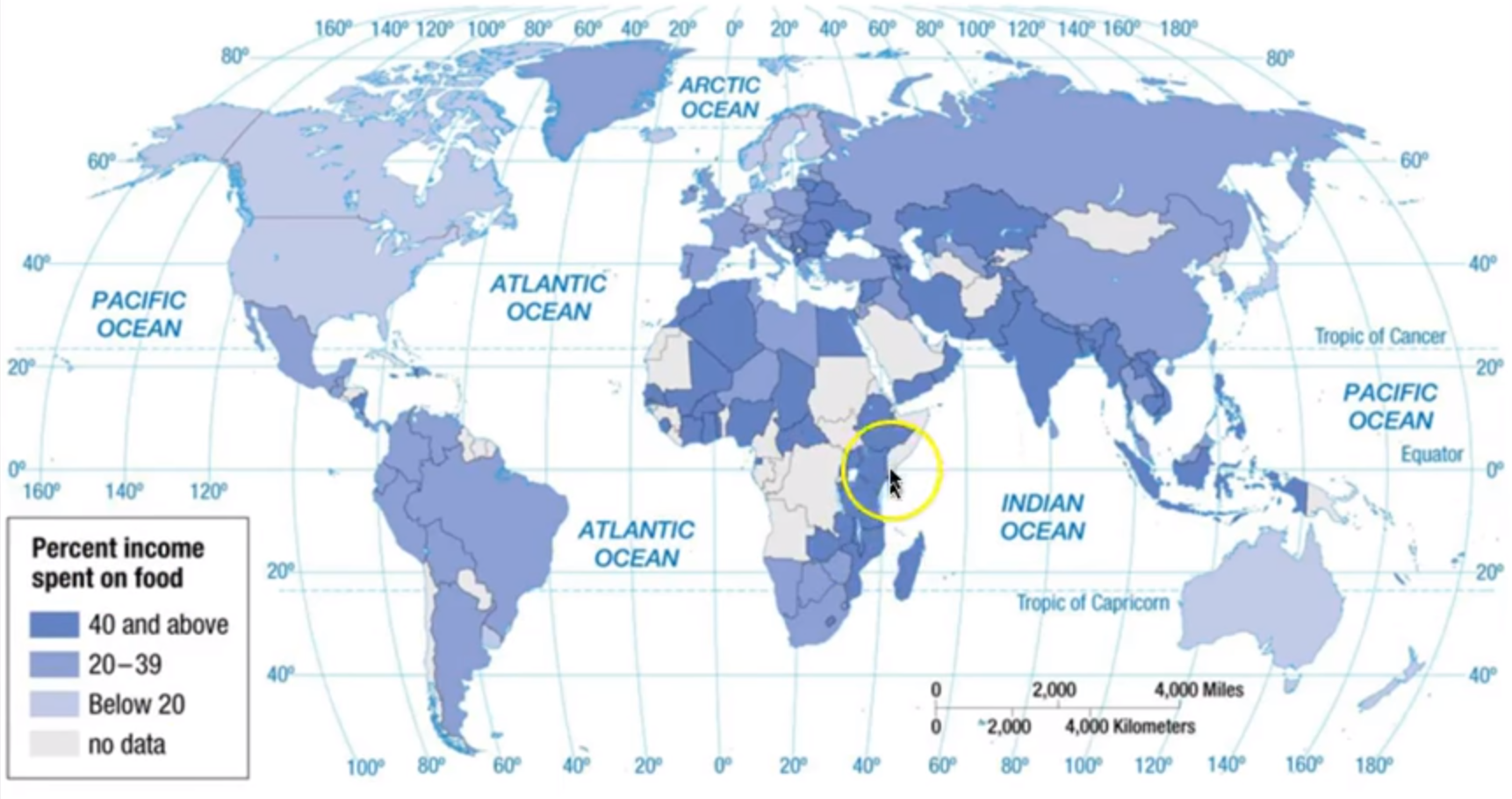
- additional notes
- food security plays a large role in LDCs
- role of women in agricultural production
- economic purpose
- changing diets
- Environmental effects of agricultural land use include pollution, land cover change, desertification, soil salinization, and conservation efforts.
5.1 Challenges of Contemporary Agriculture #
IMP Agricultural production and consumption patterns vary in different locations, presenting different environmental, social, economic, and cultural opportunities and challenges.
- Learning Objective: Explain challenges and debates related to the changing nature of contemporary agriculture and food-production practices.
- Essential Knowledge:
- Agricultural innovations such as biotechnology, genetically modified organisms, and aquaculture have been accompanied by debates over sustainability, soil and water usage, reductions in biodiversity, and extensive fertilizer and pesticide use.
- biotechnology, genetically modified organisms, and aquaculture
- technological innovations have led to much higher yield
- debates over sustainability, soil and water usage, reductions in biodiversity, and extensive fertilizer and pesticide use
- pesticides kill off good bugs, possibly whipe out entire vital species by accident
- the majority of the latest tech is avaliable only the core countries, not periphery
- agricultural diversity has been on the decline, increased chance of blight
- New, or very old, disease comes back and, because of lack of genetic diversity, most crops highly susciptible
- biotechnology, genetically modified organisms, and aquaculture
- Patterns of food production and consumption are influenced by movements relating to individual food choice, such as urban farming, community-supported agriculture (CSA), organic farming, value-added specialty crops, fair trade, local-food movements, and dietary shifts.
- urban farming
- community-supported agriculture (CSA)
- organic farming
- avoid using synthetic chemical fertilizers and GMOs
- aim to protect earth and produce safe, healthy food with “zero impact” on environment
- value-added specialty crops
- fair trade
- local-food movements
- dietary shifts
- Most typical citizen is an asian farmer who produces enough to get by
- MDCs people eat a lot more
- Cliamte affects what people eat
- MDCs this is less of an impact due to better tech making shipping faster
- LDCs can only really eat what is avaliable locally
- Cultural prefences still dictate diet
- ‘Fast-food’ diet
- Meat consumption:
- MDCs get 1/3 of protein from meat
- LDCs get 1/10 of protein from meat, rely more on grains
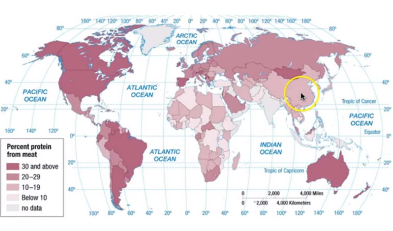
- Challenges of feeding a global population include lack of food access, as in cases of food insecurity and food deserts; problems with distribution systems; adverse weather; and land use lost to suburbanization.
- food access (food insecurity and food deserts
- problems with distribution systems
- adverse weather
- land use lost to suburbanization
- The location of food-processing facilities and markets, economies of scale, distribution systems, and government policies all have economic effects on food-production practices.
- Agricultural innovations such as biotechnology, genetically modified organisms, and aquaculture have been accompanied by debates over sustainability, soil and water usage, reductions in biodiversity, and extensive fertilizer and pesticide use.
5.1 Women in Agriculture #
IMP Agricultural production and consumption patterns vary in different locations, presenting different environmental, social, economic, and cultural opportunities and challenges.
- Learning Objective: Explain geographic variations in female roles in food production and consumption.
- Essential Knowledge:
- The role of females in food production, distribution, and consumption varies in many places depending on the type of production involved.
- Historically, Men gathered the materials and women used these materials to manufacture household objects and maintained there house
- Obstacles to equality + empowerment
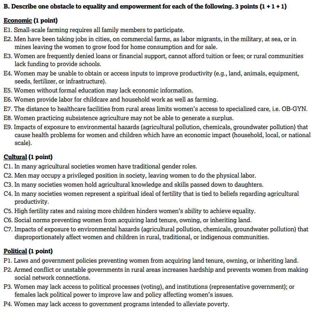
- Impact of empowerment
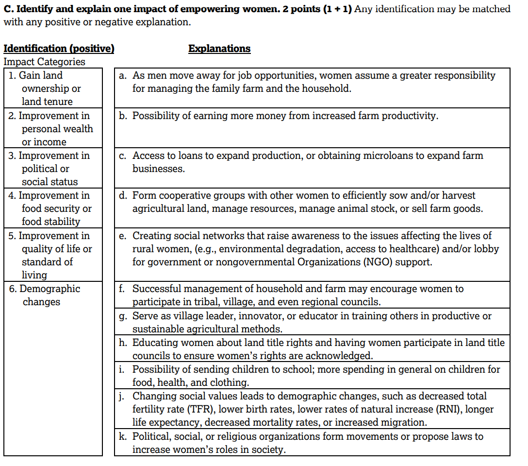
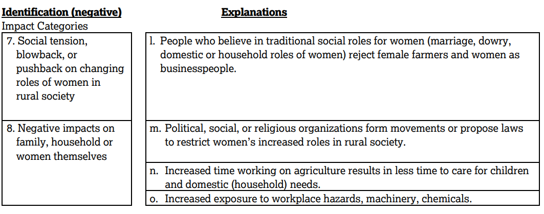
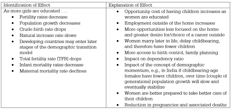 effects of this women empowerment / equality on population growth
 effects of this women empowerment / equality on economic development
 effects of this women empowerment / equality on gender roles in the developing world.
- The role of females in food production, distribution, and consumption varies in many places depending on the type of production involved.